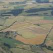
 |
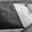
On-line Digital Images |
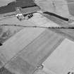
SC 395956 |
RCAHMS Aerial Photography |
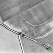
Oblique aerial view. |
5/7/1994 |
Item Level |
|
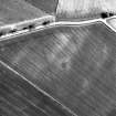 |
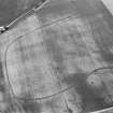
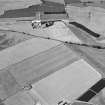
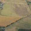
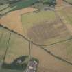
On-line Digital Images |
SC 923494 |
RCAHMS Aerial Photography |
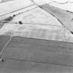
Oblique aerial view centred on the cropmarks of square and round barrows, a probable roundhouse and the central portion of a ditch-defined cursus, taken from the ENE. |
1982 |
Item Level |
|
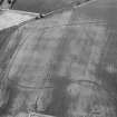 |
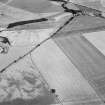
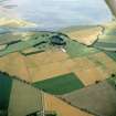
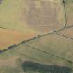
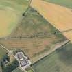
On-line Digital Images |
SC 1013391 |
Records of Aberdeen Aerial Surveys, Aberdeen, Scotland |
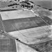
Oblique aerial view centred on the cropmarks of the enclosed settlement, ditch defined cursus, enclosure, ring ditches, barrows, pits and rig at Powis and Old Montrose with the farmstead adjacent, looking to the NW. |
5/7/1982 |
Item Level |
|
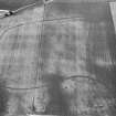 |
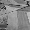
On-line Digital Images |
SC 1013392 |
Records of Aberdeen Aerial Surveys, Aberdeen, Scotland |
Oblique aerial view centred on the cropmarks of the enclosed settlement, ditch defined cursus, enclosure, ring ditches, barrows, pits and rig at Powis and Old Montrose, looking to the NW. |
5/7/1982 |
Item Level |
|
 |
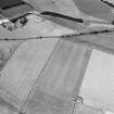
On-line Digital Images |
SC 1013393 |
Records of Aberdeen Aerial Surveys, Aberdeen, Scotland |
Oblique aerial view centred on the cropmarks of the enclosed settlement, ditch defined cursus, enclosure, ring ditches, barrows, pits and rig at Powis and Old Montrose, looking to the NW. |
5/7/1982 |
Item Level |
|
 |
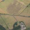
On-line Digital Images |
SC 1013825 |
Records of Aberdeen Aerial Surveys, Aberdeen, Scotland |
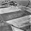
Oblique aerial view centred on the cropmarks of the enclosed settlement, ditch defined cursus, enclosure, ring ditches, barrows, pits and rig with the farmstead adjacent, looking to the NW. |
28/7/1982 |
Item Level |
|
 |
On-line Digital Images |
SC 1013826 |
Records of Aberdeen Aerial Surveys, Aberdeen, Scotland |
Oblique aerial view centred on the cropmarks of the enclosed settlement, ditch defined cursus, enclosure, ring ditches, barrows, pits and rig with the farmstead adjacent, looking to the NW. |
28/7/1982 |
Item Level |
|
 |
On-line Digital Images |
SC 1013827 |
Records of Aberdeen Aerial Surveys, Aberdeen, Scotland |
Oblique aerial view centred on the cropmarks of the enclosed settlement, ditch defined cursus, enclosure, ring ditches, barrows, pits and rig with the farmstead adjacent, looking to the WNW. |
28/7/1982 |
Item Level |
|
 |
On-line Digital Images |
SC 1013828 |
Records of Aberdeen Aerial Surveys, Aberdeen, Scotland |
Oblique aerial view centred on the cropmarks of the enclosed settlement, ditch defined cursus, enclosure, ring ditches, barrows, pits and rig with the farmstead adjacent, looking to the WNW. |
28/7/1982 |
Item Level |
|
 |
On-line Digital Images |
SC 1013829 |
Records of Aberdeen Aerial Surveys, Aberdeen, Scotland |
Oblique aerial view centred on the cropmarks of the enclosed settlement, ditch defined cursus, enclosure, ring ditches, barrows, pits and rig with the farmstead adjacent, looking to the WSW. |
28/7/1982 |
Item Level |
|
 |
On-line Digital Images |
SC 1113386 |
John Dewar |
Oblique aerial view of Old Montrose and Powis. |
7/1976 |
Item Level |
|
 |
On-line Digital Images |
SC 1113387 |
John Dewar |
Oblique aerial view of Old Montrose and Powis. |
7/1976 |
Item Level |
|
 |
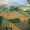
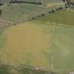
On-line Digital Images |
DP 163316 |
RCAHMS Aerial Photography Digital |
Oblique aerial view of the cropmarks of the cursus, barrows, enclosure and ring ditches, looking S. |
31/7/2013 |
Item Level |
|
 |
On-line Digital Images |
DP 163317 |
RCAHMS Aerial Photography Digital |
Oblique aerial view of the cropmarks of the cursus, barrows, enclosure and ring ditches, looking SE. |
31/7/2013 |
Item Level |
|
 |
On-line Digital Images |
DP 163318 |
RCAHMS Aerial Photography Digital |
Oblique aerial view of the cropmarks of the cursus, barrows, enclosure and ring ditches, looking SE. |
31/7/2013 |
Item Level |
|
 |
On-line Digital Images |
DP 163319 |
RCAHMS Aerial Photography Digital |
Oblique aerial view of the cropmarks of the cursus, barrows, enclosure, ring ditches and rig, looking ESE. |
31/7/2013 |
Item Level |
|
 |
On-line Digital Images |
DP 163320 |
RCAHMS Aerial Photography Digital |
Oblique aerial view of the cropmarks of the cursus, barrows, enclosure, ring ditches and rig, looking E. |
31/7/2013 |
Item Level |
|
 |
On-line Digital Images |
DP 166910 |
RCAHMS Aerial Photography Digital |
Oblique aerial view of cropmarks of the enclosures, settlement, barrows and rig, looking ESE. |
18/7/2013 |
Item Level |
|
 |
On-line Digital Images |
DP 166913 |
RCAHMS Aerial Photography Digital |
Oblique aerial view of cropmarks of the cursus, enclosures, settlement and barrows at Old Montrose, looking NW. |
18/7/2013 |
Item Level |
|
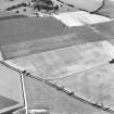 |
On-line Digital Images |
SC 1721787 |
RCAHMS Aerial Photography |
Oblique aerial view. |
1978 |
Item Level |
|
 |
On-line Digital Images |
SC 1721791 |
RCAHMS Aerial Photography |
Oblique aerial view. |
1978 |
Item Level |
|
 |
On-line Digital Images |
SC 1721792 |
RCAHMS Aerial Photography |
Oblique aerial view. |
1978 |
Item Level |
|
 |
On-line Digital Images |
SC 1721808 |
RCAHMS Aerial Photography |
Oblique aerial view. |
1982 |
Item Level |
|
 |
On-line Digital Images |
SC 1721809 |
RCAHMS Aerial Photography |
Oblique aerial view. |
1982 |
Item Level |
|


