 |
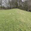
On-line Digital Images |
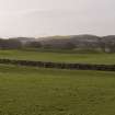
DP 268657 |
Historic Environment Scotland |
General view of the deposits to the SE of the Bush Burn, taken from the NE |
8/2/2018 |
Item Level |
|
 |
On-line Digital Images |
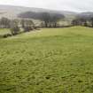
DP 268658 |
Historic Environment Scotland |
General view of the deposits to the NW of the Bush Burn, taken from the NE. The area in the centre of the image has been plough flattened. |
8/2/2018 |
Item Level |
|
 |
On-line Digital Images |
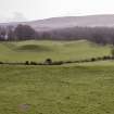
DP 268659 |
Historic Environment Scotland |
General view of the deposits to the SE of the Bush Burn, taken from the NW. |
8/2/2018 |
Item Level |
|
 |
On-line Digital Images |
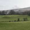
DP 268660 |
Historic Environment Scotland |
General view of the deposits to the SE of the Bush Burn, taken from the NW. |
8/2/2018 |
Item Level |
|
 |
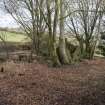
On-line Digital Images |
DP 268661 |
Historic Environment Scotland |
General view of the deposits to the NW of the Bush Burn, as they enter the woodland. Taken from the SW. |
8/2/2018 |
Item Level |
|
 |
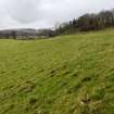
On-line Digital Images |
DP 268662 |
Historic Environment Scotland |
General view of the farmstead, overlying the natural terrace. |
8/2/2018 |
Item Level |
|
 |
On-line Digital Images |
DP 268663 |
Historic Environment Scotland |
General view of the deposits to the NW of the Bush Burn, taken from the E. |
8/2/2018 |
Item Level |
|
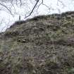 |
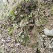
On-line Digital Images |
DP 268664 |
Historic Environment Scotland |
Detail of the S end of the deposits to the SE of the Bush Burn. Eroding section at NX 1424 8579. |
8/2/2018 |
Item Level |
|
 |
On-line Digital Images |
DP 268665 |
Historic Environment Scotland |
Detail of the deposits to the SE of the Bush Burn. Eroding section at NX 1424 8579. |
8/2/2018 |
Item Level |
|


