 |
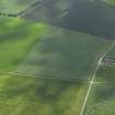
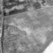
On-line Digital Images |
DP 017588 |
RCAHMS Aerial Photography Digital |
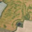
Oblique aerial view centred on the cropmarks of the unenclosed settlement, enclosures, roundhouse and possible square barrow with the cropmarks of the possible pit alignment, rig and scatter of pits adjacent, taken from the ENE. |
13/6/2006 |
Item Level |
|
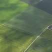 |
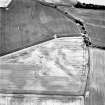
On-line Digital Images |
DP 017589 |
RCAHMS Aerial Photography Digital |
Oblique aerial view centred on the cropmarks of the unenclosed settlement, enclosures, roundhouse and possible square barrow with the cropmarks of the possible pit alignment, rig and scatter of pits adjacent, taken from the NE. |
13/6/2006 |
Item Level |
|
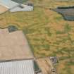 |
On-line Digital Images |
DP 166876 |
RCAHMS Aerial Photography Digital |
Oblique aerial view of the cropmarks of the palisaded settlements, round houses and pits at Ironshill, Inverkeilor, looking S. |
18/7/2013 |
Item Level |
|
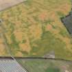 |
On-line Digital Images |
DP 166879 |
RCAHMS Aerial Photography Digital |
Oblique aerial view of the cropmarks of the palisaded settlements, round houses and pits at Ironshill, Inverkeilor, looking E. |
18/7/2013 |
Item Level |
|
 |
On-line Digital Images |
DP 166885 |
RCAHMS Aerial Photography Digital |
Oblique aerial view of the cropmarks of the unenclosed and palisaded settlements, enclosures, linear features and pits, looking SW. |
18/7/2013 |
Item Level |
|
 |
On-line Digital Images |
DP 166886 |
RCAHMS Aerial Photography Digital |
Oblique aerial view of the cropmarks of the unenclosed and palisaded settlements, enclosures, linear features and pits, looking SSE. |
18/7/2013 |
Item Level |
|
 |
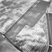
On-line Digital Images |
SC 1721131 |
RCAHMS Aerial Photography |
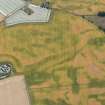
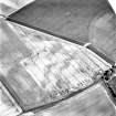
Ironshill, general oblique aerial view taken from the SW, centred on the cropmarks and the cropmarks of enclosures, possible barrows, ring-ditches, pits. The cropmarks of an unenclosed settlement are visible in the bottom right hand corner of the photograph. In the top right hand corner the cropmarks of enclosures, pits and a field system are also visible. |
8/7/1996 |
Item Level |
|
 |
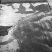
On-line Digital Images |
SC 1721181 |
RCAHMS Aerial Photography |
Oblique aerial view. |
1977 |
Item Level |
|
 |
On-line Digital Images |
SC 1721182 |
RCAHMS Aerial Photography |
Oblique aerial view. |
1977 |
Item Level |
|
 |
On-line Digital Images |
SC 1721264 |
RCAHMS Aerial Photography |
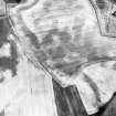
Ironshill, oblique aerial view, taken from the NW, centred on the cropmarks of an enclosure, pits and linear cropmarks. A field boundary is visible in the top left-hand corner of the photograph. |
7/1995 |
Item Level |
|
 |
On-line Digital Images |
SC 1721265 |
RCAHMS Aerial Photography |
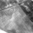
Ironshill, oblique aerial view, taken from the SW, centred on the cropmarks of an enclosure, pits and linear cropmarks. A settlement, enclosures and a field-system are visible in the top left-hand corner of the photograph. |
1995 |
Item Level |
|
 |
On-line Digital Images |
SC 1721276 |
RCAHMS Aerial Photography |
Ironshill, general oblique aerial view taken from the SE, centred on the cropmarks and the cropmarks of enclosures, possible barrows, ring-ditches, pits. The cropmarks of an unenclosed settlement are visible in the bottom left hand corner of the photograph. |
8/7/1996 |
Item Level |
|
 |
On-line Digital Images |
SC 1721277 |
RCAHMS Aerial Photography |
Ironshill, general oblique aerial view taken from the NE, centred on the cropmarks and the cropmarks of enclosures, possible barrows, ring-ditches, pits. The cropmarks of an unenclosed settlement are visible in the bottom left hand corner of the photograph. |
8/7/1996 |
Item Level |
|
 |
On-line Digital Images |
SC 1721298 |
RCAHMS Aerial Photography |
Oblique aerial view centred on the cropmarks of the enclosure, ring-ditch, linear cropmarks, pits and cropmarks, taken from the NW. |
14/8/2000 |
Item Level |
|
 |
On-line Digital Images |
SC 1721299 |
RCAHMS Aerial Photography |
Oblique aerial view centred on the cropmarks of the enclosure, ring-ditch, linear cropmarks, pits and cropmarks, taken from the NW. |
14/8/2000 |
Item Level |
|
 |
On-line Digital Images |
SC 1721300 |
RCAHMS Aerial Photography |
Oblique aerial view centred on the cropmarks of the enclosure, ring-ditch, linear cropmarks, pits and cropmarks, taken from the NNW. |
14/8/2000 |
Item Level |
|
 |
On-line Digital Images |
SC 1721301 |
RCAHMS Aerial Photography |
Oblique aerial view centred on the cropmarks of the enclosure, ring-ditch, linear cropmarks, pits and cropmarks, taken from the N. |
14/8/2000 |
Item Level |
|
 |
On-line Digital Images |
SC 1721302 |
RCAHMS Aerial Photography |
Oblique aerial view centred on the cropmarks of the enclosure, ring-ditch, linear cropmarks, pits and cropmarks, taken from the NE. |
14/8/2000 |
Item Level |
|
 |
On-line Digital Images |
SC 1721562 |
RCAHMS Aerial Photography |
Ironshill, oblique aerial view, taken from the WNW, centred on the cropmarks of an enclosure, pits and linear cropmarks. A field boundary is visible in the top right-hand corner of the photograph. |
4/7/1995 |
Item Level |
|
 |
On-line Digital Images |
SC 2409999 |
Records of the Ordnance Survey, Southampton, Hampshire, England |
Ironshill, NO64NE 15, Ordnance Survey index card, page number 1, Recto |
c. 1958 |
Item Level |
|
 |
On-line Digital Images |
SC 2410000 |
Records of the Ordnance Survey, Southampton, Hampshire, England |
Ironshill, NO64NE 15, Ordnance Survey index card, Recto |
c. 1958 |
Item Level |
|


