 |
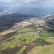
On-line Digital Images |
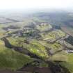
DP 099909 |
RCAHMS Aerial Photography Digital |
General oblique view of Craigtoun Park centred on The Duke's Golf Course, taken from the ENE. |
8/4/2011 |
Item Level |
|
 |
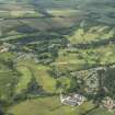
On-line Digital Images |
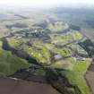
DP 099910 |
RCAHMS Aerial Photography Digital |
General oblique view of Craigtoun Park centred on The Duke's Golf Course, taken from the NE. |
8/4/2011 |
Item Level |
|
 |
On-line Digital Images |
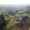
DP 099911 |
RCAHMS Aerial Photography Digital |
General oblique view of Craigtoun Park centred on The Duke's Golf Course, taken from the N. |
8/4/2011 |
Item Level |
|
 |
On-line Digital Images |
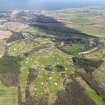
DP 099912 |
RCAHMS Aerial Photography Digital |
General oblique view of Craigtoun Park centred on The Duke's Golf Course, taken from the SW. |
8/4/2011 |
Item Level |
|
 |
On-line Digital Images |
DP 099913 |
RCAHMS Aerial Photography Digital |
General oblique view of Craigtoun Park centred on The Duke's Golf Course, taken from the SSW. |
8/4/2011 |
Item Level |
|
 |
On-line Digital Images |
DP 191796 |
RCAHMS Aerial Photography Digital |
General oblique aerial view of The Duke's Course, Craigtoun Park, looking SW. |
23/6/2014 |
Item Level |
|
|
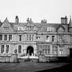
Photographs and Off-line Digital Images |
DP 204290 |
Buildings at Risk Register |
From West |
15/7/2014 |
Item Level |
|
|
Photographs and Off-line Digital Images |
DP 204291 |
Buildings at Risk Register |
From East |
15/7/2014 |
Item Level |
|
|
Photographs and Off-line Digital Images |
DP 204292 |
Buildings at Risk Register |
From North |
15/7/2014 |
Item Level |
|
|
Photographs and Off-line Digital Images |
DP 204293 |
Buildings at Risk Register |
From South |
15/7/2014 |
Item Level |
|
|
Photographs and Off-line Digital Images |
DP 204294 |
Buildings at Risk Register |
From South East |
15/7/2014 |
Item Level |
|
 |
On-line Digital Images |
SC 1636837 |
List C Survey |
Entrance (west) elevation, including sundial |
1975 |
Item Level |
|
 |
On-line Digital Images |
SC 1636840 |
List C Survey |
View from south east |
1975 |
Item Level |
|
 |
On-line Digital Images |
SC 1636841 |
List C Survey |
View from north east |
1975 |
Item Level |
|
|
Photographs and Off-line Digital Images |
DP 302438 |
Historic Environment Scotland |
From South, with conservatory. |
13/6/2019 |
Item Level |
|
|
Photographs and Off-line Digital Images |
DP 302439 |
Historic Environment Scotland |
From South |
13/6/2019 |
Item Level |
|
|
Photographs and Off-line Digital Images |
DP 302440 |
Historic Environment Scotland |
From West |
13/6/2019 |
Item Level |
|
 |
On-line Digital Images |
SC 2405513 |
Records of the Ordnance Survey, Southampton, Hampshire, England |
Craigtoun Park, NO41SE 11, Ordnance Survey index card, Recto |
c. 1958 |
Item Level |
|
 |
On-line Digital Images |
SC 2513723 |
|
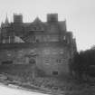
East elevation |
c. 1950 |
Item Level |
|
 |
On-line Digital Images |
SC 2513724 |
|
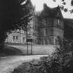
Part view of Mount Melville from north east |
c. 1950 |
Item Level |
|
|
All Other |
551 1/4/7/15/18 |
Records of the Royal Commission on the Ancient and Historical Monuments of Scotland (RCAHMS), Edinbu |
Craigtoun House |
7/11/2007 |
Sub-Group Level |
|
|
All Other |
551 1/4/7/15/40 |
Records of the Royal Commission on the Ancient and Historical Monuments of Scotland (RCAHMS), Edinbu |
Craigtoun Park |
2007 |
Sub-Group Level |
|


