 |
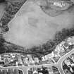
On-line Digital Images |
SC 1717119 |
RCAHMS Aerial Photography |
Oblique aerial view |
1976 |
Item Level |
|
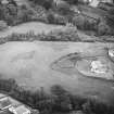 |
On-line Digital Images |
SC 1717120 |
RCAHMS Aerial Photography |
Oblique aerial view |
1976 |
Item Level |
|
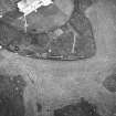 |
On-line Digital Images |
SC 1717121 |
RCAHMS Aerial Photography |
Oblique aerial view |
1976 |
Item Level |
|
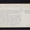 |
On-line Digital Images |
SC 2405364 |
Records of the Ordnance Survey, Southampton, Hampshire, England |
Hallow Hill, St Andrews, NO41NE 8, Ordnance Survey index card, page number 1, Recto |
1958 |
Item Level |
|
 |
On-line Digital Images |
SC 2405365 |
Records of the Ordnance Survey, Southampton, Hampshire, England |
Hallow Hill, St Andrews, NO41NE 8, Ordnance Survey index card, page number 2, Verso |
1958 |
Item Level |
|
 |
On-line Digital Images |
SC 2405366 |
Records of the Ordnance Survey, Southampton, Hampshire, England |
Hallow Hill, St Andrews, NO41NE 8, Ordnance Survey index card, Recto |
1958 |
Item Level |
|
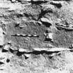 |
On-line Digital Images |
SC 2576627 |
St Andrews Heritage Services |
Hallow Hill, St Andrews
Cist 70: N edge from S.
Cist 70: prior to excavation. |
1977 |
Item Level |
|


