 |
On-line Digital Images |
DP 209604 |
RCAHMS Aerial Photography Digital |
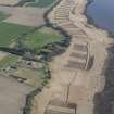
Oblique aerial view of the reed beds on the River Tay between Seaside House and Powgavie, looking NE. |
17/4/2015 |
Item Level |
|
 |
On-line Digital Images |
DP 209603 |
RCAHMS Aerial Photography Digital |
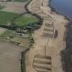
Oblique aerial view of the reed beds on the River Tay between Seaside House and Powgavie, looking NE. |
17/4/2015 |
Item Level |
|
 |
On-line Digital Images |
SC 2400896 |
Records of the Ordnance Survey, Southampton, Hampshire, England |
Powgavie, Harbour, NO22NE 20, Ordnance Survey index card, Recto |
c. 1958 |
Item Level |
|
 |
On-line Digital Images |
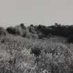
SC 2640361 |
|
View of site of overgrown quay. |
1968 |
Item Level |
|


