 |
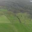
On-line Digital Images |
DP 056411 |
RCAHMS Aerial Photography Digital |
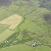
General oblique aerial view of the remains of the farmsteads and fields at Castlehill on Rousay, taken from the NNW. |
24/9/2008 |
Item Level |
|
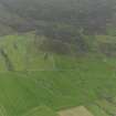 |
On-line Digital Images |
DP 056412 |
RCAHMS Aerial Photography Digital |
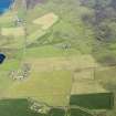
General oblique aerial view of the remains of the chambered cairn, farmsteads and fields at Knowe of Lingro on Rousay, taken from the N. |
24/9/2008 |
Item Level |
|
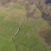 |
On-line Digital Images |
DP 059734 |
RCAHMS Aerial Photography Digital |
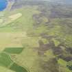
Oblique aerial view centred on the ruined farmsteads of Burness, Castlehill, Turbitail, Upper Burness and Whitemeadows, taken from the SE. |
12/5/2009 |
Item Level |
|
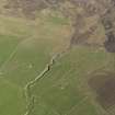 |
On-line Digital Images |
DP 059735 |
RCAHMS Aerial Photography Digital |
Oblique aerial view centred on the ruined farmsteads of Burness, Castlehill, Turbitail, Upper Burness and Whitemeadows, taken from the SE. |
12/5/2009 |
Item Level |
|
 |
On-line Digital Images |
DP 244331 |
Historic Environment Scotland |
Oblique aerial view. |
16/8/2016 |
Item Level |
|
 |
On-line Digital Images |
DP 244332 |
Historic Environment Scotland |
Oblique aerial view. |
16/8/2016 |
Item Level |
|
 |
On-line Digital Images |
DP 244333 |
Historic Environment Scotland |
Oblique aerial view. |
16/8/2016 |
Item Level |
|


