
Pricing Change
New pricing for orders of material from this site will come into place shortly. Charges for supply of digital images, digitisation on demand, prints and licensing will be altered.
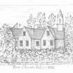
Killin, Former Free Church


Church (19th Century) - (20th Century), School (20th Century)
Site Name Killin, Former Free Church
Classification Church (19th Century) - (20th Century), School (20th Century)
Alternative Name(s) Former Free Church
Canmore ID 297600
Site Number NN53SE 104
NGR NN 57249 33010
Datum OSGB36 - NGR
Permalink http://canmore.org.uk/site/297600

- Council Stirling
- Parish Killin
- Former Region Central
- Former District Stirling
- Former County Perthshire
Former Free Church building, now a bank
Note (14 February 2025)
A church is depicted on the 1st edition of the OS 25-inch map (1867) - Perth and Clackmannanshire LXXX.2 (Killin). The church was demolished and a primary school is visible at this location on OS MasterMap (viewed 14 February 2025).
Information from HES (D Watson) 14 February 2025

