 |
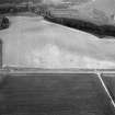
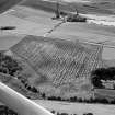
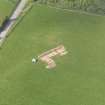
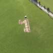
On-line Digital Images |
SC 1001600 |
Records of Aberdeen Aerial Surveys, Aberdeen, Scotland |
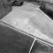
Oblique aerial view centred on the cropmarks of the circular enclosure at Barflat, looking to the ESE. |
16/7/1983 |
Item Level |
|
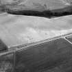 |
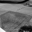
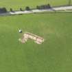
On-line Digital Images |
SC 1001601 |
Records of Aberdeen Aerial Surveys, Aberdeen, Scotland |
Oblique aerial view centred on the cropmarks of the circular enclosure at Barflat, looking to the SE. |
16/7/1983 |
Item Level |
|
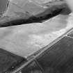 |
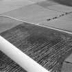
On-line Digital Images |
SC 1001602 |
Records of Aberdeen Aerial Surveys, Aberdeen, Scotland |
Oblique aerial view centred on the cropmarks of the circular enclosure at Barflat, looking to the SSE. |
16/7/1983 |
Item Level |
|
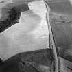 |
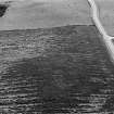
On-line Digital Images |
SC 1001603 |
Records of Aberdeen Aerial Surveys, Aberdeen, Scotland |
Oblique aerial view centred on the cropmarks of the circular enclosure at Barflat, looking to the SSW. |
16/7/1983 |
Item Level |
|
 |
On-line Digital Images |
SC 1001604 |
Records of Aberdeen Aerial Surveys, Aberdeen, Scotland |
Oblique aerial view centred on the cropmarks of the circular enclosure at Barflat, looking to the ENE. |
16/7/1983 |
Item Level |
|
 |
On-line Digital Images |
SC 1011728 |
Records of Aberdeen Aerial Surveys, Aberdeen, Scotland |
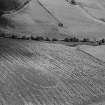
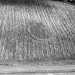
Oblique aerial view centred on the cropmarks of the circular enclosure at Barflat, looking to the SE. |
22/8/1978 |
Item Level |
|
 |
On-line Digital Images |
SC 1011729 |
Records of Aberdeen Aerial Surveys, Aberdeen, Scotland |
Oblique aerial view centred on the cropmarks of the circular enclosure at Barflat, looking to the ESE. |
22/8/1978 |
Item Level |
|
 |
On-line Digital Images |
SC 1011730 |
Records of Aberdeen Aerial Surveys, Aberdeen, Scotland |
Oblique aerial view centred on the cropmarks of the circular enclosure at Barflat, looking to the NNE. |
22/8/1978 |
Item Level |
|
 |
On-line Digital Images |
SC 1011753 |
Records of Aberdeen Aerial Surveys, Aberdeen, Scotland |
Oblique aerial view centred on the cropmarks of the circular enclosure at Barflat, looking to the WSW. |
22/8/1978 |
Item Level |
|
 |
On-line Digital Images |
SC 1011754 |
Records of Aberdeen Aerial Surveys, Aberdeen, Scotland |
Oblique aerial view centred on the cropmarks of the circular enclosure at Barflat, looking to the WSW. |
22/8/1978 |
Item Level |
|
 |
On-line Digital Images |
SC 1011755 |
Records of Aberdeen Aerial Surveys, Aberdeen, Scotland |
Oblique aerial view centred on the cropmarks of the circular enclosure at Barflat, looking to the SW. |
22/8/1978 |
Item Level |
|
 |
On-line Digital Images |
SC 1011756 |
Records of Aberdeen Aerial Surveys, Aberdeen, Scotland |
Oblique aerial view centred on the cropmarks of the circular enclosure at Barflat, looking to the SSW. |
22/8/1978 |
Item Level |
|
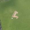 |
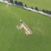
On-line Digital Images |
DP 108808 |
RCAHMS Aerial Photography Digital |
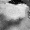
Oblique aerial view centred on the excavation of the enclosures at Barflat, Rhynie, taken from the SSW. |
30/4/2011 |
Item Level |
|
 |
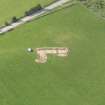
On-line Digital Images |
DP 108809 |
RCAHMS Aerial Photography Digital |
Oblique aerial view centred on the excavation of the enclosures at Barflat, Rhynie, taken from the S. |
30/4/2011 |
Item Level |
|
 |
On-line Digital Images |
DP 108810 |
RCAHMS Aerial Photography Digital |
Oblique aerial view centred on the excavation of the enclosures at Barflat, Rhynie, taken from the SE. |
30/4/2011 |
Item Level |
|
 |
On-line Digital Images |
DP 108811 |
RCAHMS Aerial Photography Digital |
Oblique aerial view centred on the excavation of the enclosures at Barflat, Rhynie, taken from the ESE. |
30/4/2011 |
Item Level |
|
 |
On-line Digital Images |
DP 108812 |
RCAHMS Aerial Photography Digital |
Oblique aerial view centred on the excavation of the enclosures at Barflat, Rhynie, taken from the ENE. |
30/4/2011 |
Item Level |
|
 |
On-line Digital Images |
DP 108813 |
RCAHMS Aerial Photography Digital |
Oblique aerial view centred on the excavation of the enclosures at Barflat, Rhynie, taken from the NE. |
30/4/2011 |
Item Level |
|
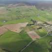 |
On-line Digital Images |
DP 108814 |
RCAHMS Aerial Photography Digital |
General oblique aerial view looking across the excavation of the enclosures at Barflat, with Rhynie village and Tap O'Noth beyond, taken from the SSE. |
30/4/2011 |
Item Level |
|
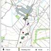 |
On-line Digital Images |
DP 234424 |
Records of the Royal Commission on the Ancient and Historical Monuments of Scotland (RCAHMS), Edinbu |
This map shows the location of sites and monuments around the village of Rhynie. |
2007 |
Item Level |
|
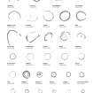 |
On-line Digital Images |
DP 234452 |
Records of the Royal Commission on the Ancient and Historical Monuments of Scotland (RCAHMS), Edinbu |
Plans transcribed from aerial photographs of circular and oval enclosures in north-east Scotland. |
2007 |
Item Level |
|


