 |
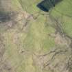
On-line Digital Images |
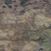
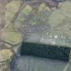
DP 226354 |
RCAHMS Aerial Photography Digital |
Oblique aerial view of the townships, field system and rig at Gleann Fearnach on the slopes of Creag Dubh Leitir, looking S. |
25/5/2015 |
Item Level |
|
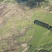 |
On-line Digital Images |
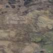
DP 226358 |
RCAHMS Aerial Photography Digital |
Oblique aerial view of the townships, field system and rig at Gleann Fearnach on the slopes of Creag Dubh Leitir, looking E. |
25/5/2015 |
Item Level |
|
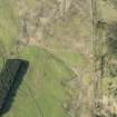 |
On-line Digital Images |
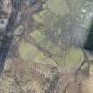
DP 226361 |
RCAHMS Aerial Photography Digital |
Oblique aerial view of the townships, field system and rig at Gleann Fearnach on the slopes of Creag Dubh Leitir, looking NNE. |
25/5/2015 |
Item Level |
|
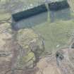 |
On-line Digital Images |
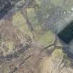
DP 228942 |
Historic Environment Scotland |
Oblique aerial view of the townships, farmsteads, field boundaries and rig at Craig Dubh-Leitir, looking SE. |
15/1/2016 |
Item Level |
|
 |
On-line Digital Images |
DP 228945 |
Historic Environment Scotland |
Oblique aerial view of the farmsteads, field boundaries and rig at Craig Dubh-Leitir, looking ENE. |
15/1/2016 |
Item Level |
|
 |
On-line Digital Images |
DP 228946 |
Historic Environment Scotland |
Oblique aerial view of the farmsteads, field boundaries and rig at Craig Dubh-Leitir, looking ENE. |
15/1/2016 |
Item Level |
|
 |
On-line Digital Images |
DP 228948 |
Historic Environment Scotland |
Oblique aerial view of the townships, farmsteads, field boundaries and rig at Craig Dubh-Leitir, looking SSW. |
15/1/2016 |
Item Level |
|
 |
On-line Digital Images |
DP 228950 |
Historic Environment Scotland |
Oblique aerial view of the townships, farmsteads, field boundaries and rig at Craig Dubh-Leitir, looking SSE. |
15/1/2016 |
Item Level |
|
 |
On-line Digital Images |
DP 228953 |
Historic Environment Scotland |
Oblique aerial view of the townships, farmsteads, field boundaries and rig at Craig Dubh-Leitir, looking ESE. |
15/1/2016 |
Item Level |
|
 |
On-line Digital Images |
SC 2395847 |
Records of the Ordnance Survey, Southampton, Hampshire, England |
Creag Dubh-Leitir, Gleann Fearnach, NO06SE 30, Ordnance Survey index card, Recto |
c. 1958 |
Item Level |
|
 |
On-line Digital Images |
SC 2395848 |
Records of the Ordnance Survey, Southampton, Hampshire, England |
Creag Dubh-Leitir, Gleann Fearnach, NO06SE 30, Ordnance Survey index card, Recto |
c. 1958 |
Item Level |
|


