 |
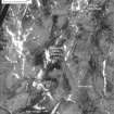
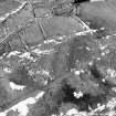
On-line Digital Images |
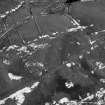
SC 1008100 |
RCAHMS Aerial Photography |
Oblique aerial view of the Roman temporary camp, bank barrow and enclosures at Raeburnfoot |
14/2/1996 |
Item Level |
|
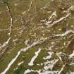 |
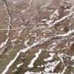
On-line Digital Images |
SC 1008107 |
RCAHMS Aerial Photography |
Oblique aerial view of the Roman temporary camp, bank barrow and enclosures at Raeburnfoot |
14/2/1996 |
Item Level |
|
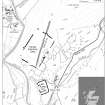 |
On-line Digital Images |
SC 1124705 |
Records of the Royal Commission on the Ancient and Historical Monuments of Scotland (RCAHMS), Edinbu |
Map depicting Raeburnfoot Roman Temporary Camp within its surrounding landscape. publication. Greyscale Tif file. 1200 dpi |
27/10/2008 |
Item Level |
|
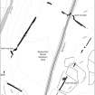 |
On-line Digital Images |
SC 1124707 |
Records of the Royal Commission on the Ancient and Historical Monuments of Scotland (RCAHMS), Edinbu |
Detailed map depicting Raeburnfoot Roman Temporary Camp. Created for publication. Greyscale Tif file. 1200 dpi. |
28/10/2008 |
Item Level |
|
 |
On-line Digital Images |
SC 1124709 |
Records of the Royal Commission on the Ancient and Historical Monuments of Scotland (RCAHMS), Edinbu |
Rectified version of aerial photograph SC1008108 showing Raeburnfoot Roman Temporary Camp. The view shown is the same as that depicted on map SC1124707. Created for publication. Greyscale Tif file. |
28/10/2008 |
Item Level |
|
 |
On-line Digital Images |
SC 1124713 |
Records of the Royal Commission on the Ancient and Historical Monuments of Scotland (RCAHMS), Edinbu |
View of the digital terrain model of the North-west, Stracathro type, gate of Raeburnfoot Roman Temporary Camp. Created in Arcscene. Created for publication. Greyscale Tif file. |
28/10/2008 |
Item Level |
|
 |
On-line Digital Images |
SC 1124716 |
Records of the Royal Commission on the Ancient and Historical Monuments of Scotland (RCAHMS), Edinbu |
Distribution map showing all Roman Temporary Camps in Scotland with Stracathro type gates, highlighting Raeburnfoot Roman Temporary Camp. Created for publication. Greyscale Tif file. 1200 dpi |
28/10/2008 |
Item Level |
|
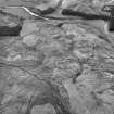 |
On-line Digital Images |
SC 1124867 |
RCAHMS Aerial Photography |
Raeburnfoot, oblique aerial view, taken from the NE, centred on the bank barrow and Raeburnfoot Roman Temporary Camp. The Reaburnfoot Roman Fort, and enclosures at Kiln Syke, are visible in the top left-hand corner of the photograph. |
15/12/1995 |
Item Level |
|
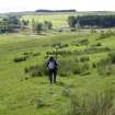 |
On-line Digital Images |
DP 267364 |
RCAHMS Field Survey Digital Photography |
Archaeological field survey in progress along SW side of Roman temporary camp. |
27/6/2005 |
Item Level |
|
 |
On-line Digital Images |
DP 267365 |
RCAHMS Field Survey Digital Photography |
View of NW gate of Roman temporary camp. |
28/6/2005 |
Item Level |
|
 |
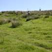
On-line Digital Images |
DP 267367 |
RCAHMS Field Survey Digital Photography |
View from NE of the upstanding earthwoks of the NW gate of the Roman temporary camp. |
28/6/2005 |
Item Level |
|
 |
On-line Digital Images |
DP 267368 |
RCAHMS Field Survey Digital Photography |
Archaeological field survey in progress at NW gate of Roman temporary camp. View from W. |
28/6/2005 |
Item Level |
|
 |
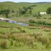
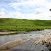
On-line Digital Images |
DP 267369 |
RCAHMS Field Survey Digital Photography |
The location of Raeburnfoot Roman temporary camp occupies the low ridge behind the farmhouse. The Roman fort is visible between the river and the farmhouse. View from SSE. |
1/7/2005 |
Item Level |
|
 |
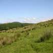
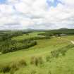
On-line Digital Images |
DP 267370 |
RCAHMS Field Survey Digital Photography |
The Roman temporary camp occupies a low ridge overlooking the River White Esk. View from W. |
1/7/2005 |
Item Level |
|
 |
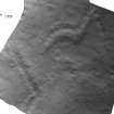
On-line Digital Images |
SC 1761121 |
RCAHMS Aerial Photography |
Raeburnfoot, oblique aerial view, taken from the NNW, centred on a bank barrow, an enclosure and field banks. |
14/2/1996 |
Item Level |
|
 |
On-line Digital Images |
SC 1761155 |
RCAHMS Aerial Photography |
Raeburnfoot, oblique aerial view, taken from the NW, centred on the bank barrow. An enclosure and field-banks are visible in the top centre the photograph. |
14/2/1996 |
Item Level |
|
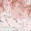 |
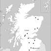
On-line Digital Images |
SC 1917768 |
Records of the Royal Commission on the Ancient and Historical Monuments of Scotland (RCAHMS), Edinbu |
Map showing the distribution of Roman monuments in Annandale and Eskdale. Published in Eastern Dumfriesshire: an archaeological landscape. |
1996 |
Item Level |
|


