 |
On-line Digital Images |
SC 370279 |
Records of the Royal Commission on the Ancient and Historical Monuments of Scotland (RCAHMS), Edinbu |
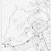
Publication drawing; map of hut circles, field system and Pitcarmick-type buildings at Balnabroich. Photographic copy. |
c. 1988 |
Item Level |
|
 |
On-line Digital Images |
SC 1707441 |
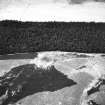
RCAHMS Aerial Photography |
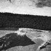
Oblique aerial view. |
1988 |
Item Level |
|
 |
On-line Digital Images |
SC 1707442 |
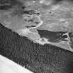
RCAHMS Aerial Photography |
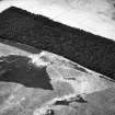
Oblique aerial view. |
1988 |
Item Level |
|
 |
On-line Digital Images |
SC 1707443 |
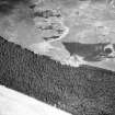
RCAHMS Aerial Photography |
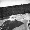
Oblique aerial view. |
1988 |
Item Level |
|
 |
On-line Digital Images |
SC 1707444 |
RCAHMS Aerial Photography |
Oblique aerial view. |
1988 |
Item Level |
|
 |
On-line Digital Images |
SC 1707524 |
RCAHMS Aerial Photography |
Oblique aerial view. |
1988 |
Item Level |
|
 |
On-line Digital Images |
SC 1710565 |
RCAHMS Aerial Photography |
Oblique aerial view. |
1988 |
Item Level |
|
 |
On-line Digital Images |
SC 2395446 |
Records of the Ordnance Survey, Southampton, Hampshire, England |
Balnabroich, NO05NE 39, Ordnance Survey index card, Recto |
c. 1958 |
Item Level |
|


