 |
On-line Digital Images |
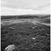
SC 531343 |
|
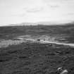
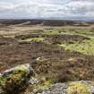
Hut-circle 4 (NO 0764 4847) |
|
Item Level |
|
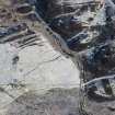 |
On-line Digital Images |
DP 228973 |
Historic Environment Scotland |
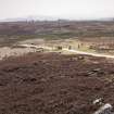
Oblique aerial view of the hut circles, buildings, field system and rig at Craigend, looking NNE. |
15/1/2016 |
Item Level |
|
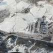 |
On-line Digital Images |
DP 228976 |
Historic Environment Scotland |
Oblique aerial view of the hut circles, buildings, field system and rig at Craigend, looking WSW. |
15/1/2016 |
Item Level |
|
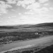 |
On-line Digital Images |
SC 2252170 |
RCAHMS Aerial Photography |
Hut-circle 4 (NO 0764 4847) |
1988 |
Item Level |
|
 |
On-line Digital Images |
SC 2252173 |
RCAHMS Aerial Photography |
Hut-circle 4 (NO 0764 4847) |
1988 |
Item Level |
|
 |
On-line Digital Images |
SC 2252193 |
RCAHMS Aerial Photography |
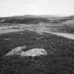
Hut-circles 1 (NO 0760 4844) and 4 (NO 0764 4847) |
1988 |
Item Level |
|
 |
On-line Digital Images |
SC 2252194 |
RCAHMS Aerial Photography |
Hut-circle 4 (NO 0764 4847) |
1988 |
Item Level |
|
 |
On-line Digital Images |
DP 396005 |
Historic Environment Scotland |
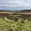
View of Hut Circle NO04NE 6.04 at NO 0764 4847 from N |
16/5/2023 |
Item Level |
|
 |
On-line Digital Images |
DP 396008 |
Historic Environment Scotland |
View of Hut Circles NO04NE 6.04 at NO 0764 4847 and NO04NE 6.01 at NO 0760 4844 from ENE |
16/5/2023 |
Item Level |
|
 |
On-line Digital Images |
SC 2679616 |
Records of the Ordnance Survey, Southampton, Hampshire, England |
Craigend, NO04NE 6.04, Ordnance Survey index card, page number 1, Recto |
c. 1958 |
Item Level |
|
 |
On-line Digital Images |
SC 2679617 |
Records of the Ordnance Survey, Southampton, Hampshire, England |
Craigend, NO04NE 6.04, Ordnance Survey index card, page number 2, Recto |
c. 1958 |
Item Level |
|


