 |
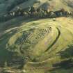
On-line Digital Images |
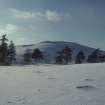
SC 721261 |
Papers of Helen Cameron Nisbet, geologist and archaeologist, Lasswade, Midlothian, Scotland |
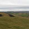
Copy of colour slide showing view of Castle Law,Forgandenny, Tayside, view of fort from east.
NMRS Survey of Private Collection
Digital Image Only |
25/2/1968 |
Item Level |
|
 |
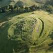
On-line Digital Images |
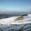
SC 721281 |
Papers of Helen Cameron Nisbet, geologist and archaeologist, Lasswade, Midlothian, Scotland |
Copy of colour slide showing general view of Castle Law, Forgandenny, Tayside, view of fort from SW.
NMRS Survey of Private Collection
Digital Image Only |
25/2/1968 |
Item Level |
|
 |
On-line Digital Images |
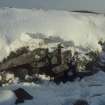
SC 721285 |
Papers of Helen Cameron Nisbet, geologist and archaeologist, Lasswade, Midlothian, Scotland |
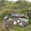
Copy of colour slide showing detail of Castle Law, Forgandenny, Tayside; insc " inner face of inner wall at E end. Note massive stones, looseness of build"
NMRS Survey of Private Collection
Digital Image Only |
25/2/1968 |
Item Level |
|
 |
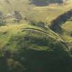
On-line Digital Images |
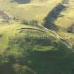
DP 056542 |
RCAHMS Aerial Photography Digital |
Oblique aerial view centred on the remains of the fort and excavation trenches, with the remains of the framstead adjacent, taken from the N. |
22/10/2008 |
Item Level |
|
 |
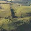
On-line Digital Images |
DP 056543 |
RCAHMS Aerial Photography Digital |
Oblique aerial view centred on the remains of the fort and excavation trenches, with the remains of the framstead adjacent, taken from the NW. |
22/10/2008 |
Item Level |
|
 |
On-line Digital Images |
DP 056544 |
RCAHMS Aerial Photography Digital |
Oblique aerial view centred on the remains of Castle Law fort and excavation trenches, taken from the W. |
22/10/2008 |
Item Level |
|
 |
On-line Digital Images |
DP 056545 |
RCAHMS Aerial Photography Digital |
Oblique aerial view centred on the remains of the fort and excavation trenches, taken from the SW. |
22/10/2008 |
Item Level |
|
 |
On-line Digital Images |
DP 056546 |
RCAHMS Aerial Photography Digital |
General oblique aerial view centred on the remains of the fort and excavation trenches, taken from the NE. |
22/10/2008 |
Item Level |
|
 |
On-line Digital Images |
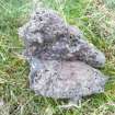
DP 072360 |
RCAHMS Field Survey Digital Photography |
Example of vitrified rock found in the debris below the outermost timber-laced wall on the South side of the fort. |
6/10/2009 |
Item Level |
|
 |
On-line Digital Images |
DP 072362 |
RCAHMS Field Survey Digital Photography |
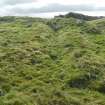
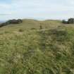
General view looking NW across the terrace on the N side of the fort. The remains of a large circular timber building can be seen in the centre left of the image. |
5/10/2009 |
Item Level |
|
 |
On-line Digital Images |
DP 072364 |
RCAHMS Field Survey Digital Photography |
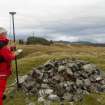
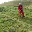
General view of Mr Ian Parker (RCAHMS) using differential GPS to survey a small cairn overlying the inner wall of the timber-laced fort. |
6/10/2009 |
Item Level |
|
 |
On-line Digital Images |
DP 072368 |
RCAHMS Field Survey Digital Photography |
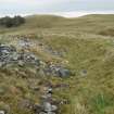
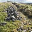
Example of surviving wall-face of one of the timber-laced walls. |
5/10/2009 |
Item Level |
|
 |
On-line Digital Images |
DP 072372 |
RCAHMS Field Survey Digital Photography |
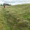
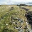
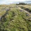
General view looking E of the inner and outer timber-laced walls on the S side of the fort. |
6/10/2009 |
Item Level |
|
 |
On-line Digital Images |
DP 072374 |
RCAHMS Field Survey Digital Photography |
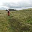
Mr Ian Parker (RCAHMS) using differential GPS to survey a late 19th century excavation trench cutting through a circular house platform on the N side of the timber-laced fort. |
6/10/2009 |
Item Level |
|
 |
On-line Digital Images |
DP 072376 |
RCAHMS Field Survey Digital Photography |
View from W of Mr Ian Parker (RCAHMS) using differential GPS to survey a late 19th century excavation trench cutting through a circular house platform on the N side of the timber-laced fort. |
6/10/2009 |
Item Level |
|
 |
On-line Digital Images |
DP 072378 |
RCAHMS Field Survey Digital Photography |
View of Mr Ian Parker (RCAHMS) using differential GPS to survey a late 19th century excavation trench at the W end of the timber-laced fort. |
6/10/2009 |
Item Level |
|
 |
On-line Digital Images |
DP 072380 |
RCAHMS Field Survey Digital Photography |
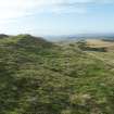
General view from W of the innermost timber-laced wall at the SE corner of the fort. |
6/10/2009 |
Item Level |
|
 |
On-line Digital Images |
DP 072382 |
RCAHMS Field Survey Digital Photography |
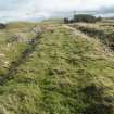
General view from W of the timber-laced walls on the S side of the fort, showing the late 19th century excavation trenches. |
6/10/2009 |
Item Level |
|
 |
On-line Digital Images |
DP 072384 |
RCAHMS Field Survey Digital Photography |
General view from W of the timber-laced walls on the S side of the fort, showing the late 19th century excavation trenches. |
6/10/2009 |
Item Level |
|
 |
On-line Digital Images |
DP 072386 |
RCAHMS Field Survey Digital Photography |
General view from W of the timber-laced walls on the S side of the fort, showing the late 19th century excavation trenches. |
6/10/2009 |
Item Level |
|
 |
On-line Digital Images |
DP 072388 |
RCAHMS Field Survey Digital Photography |
General view from W of the timber-laced walls on the S side of the fort, showing the late 19th century excavation trenches. |
6/10/2009 |
Item Level |
|
 |
On-line Digital Images |
DP 072390 |
RCAHMS Field Survey Digital Photography |
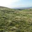
View from W of a circular house-platform that overlies the remains of the outer timber-laced wall on the N side of the fort. |
6/10/2009 |
Item Level |
|
 |
On-line Digital Images |
DP 072392 |
RCAHMS Field Survey Digital Photography |
View looking W along the outside of the inner timber-laced wall. A platform for a circular timber house is visible in the foreground. |
6/10/2009 |
Item Level |
|
 |
On-line Digital Images |
DP 072394 |
RCAHMS Field Survey Digital Photography |
View from E of one of the circular timber-houses in the enclosure attached to the N side of the timber-laced fort. |
6/10/2009 |
Item Level |
|


