 |
On-line Digital Images |
SC 884115 |
RCAHMS Aerial Photography |
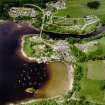
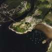
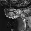
Oblique aerial view of Kenmore centred on the road bridge, church and hotel, and the remains of a crannog with Kenmore Village adjacent, taken from the SW. |
3/6/1998 |
Item Level |
|
 |
On-line Digital Images |
DP 142834 |
RCAHMS Aerial Photography Digital |
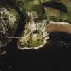
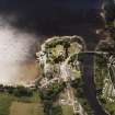
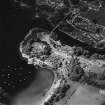
Oblique aerial view of the reconstruction of the crannog and the Isle of Spar, looking SSW. |
25/7/2012 |
Item Level |
|
 |
On-line Digital Images |
SC 1689603 |
RCAHMS Aerial Photography |
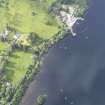
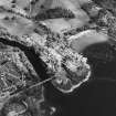
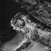
Oblique aerial view of Kenmore centred on the road bridge, church and hotel, and the remains of a crannog with Kenmore Village adjacent, taken from the WSW. |
3/6/1998 |
Item Level |
|
 |
On-line Digital Images |
SC 1689604 |
RCAHMS Aerial Photography |
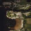
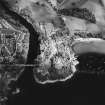
Oblique aerial view of Kenmore centred on the road bridge, church and hotel, and the remains of a crannog with Kenmore Village adjacent, taken from the SW. |
3/6/1998 |
Item Level |
|
 |
On-line Digital Images |
SC 1689605 |
RCAHMS Aerial Photography |
Oblique aerial view of Kenmore centred on the road bridge, church and hotel, and the remains of a crannog with Kenmore Village adjacent, taken from the SSW. |
3/6/1998 |
Item Level |
|
 |
On-line Digital Images |
SC 1689606 |
RCAHMS Aerial Photography |
Oblique aerial view of Kenmore centred on the road bridge, church and hotel, and the remains of a crannog with Kenmore Village adjacent, taken from the ENE. |
3/6/1998 |
Item Level |
|
 |
On-line Digital Images |
SC 1700945 |
RCAHMS Aerial Photography |
Oblique aerial view of Kenmore centred on the road bridge, church and hotel, and the remains of a crannog with Kenmore Village adjacent, taken from the W. |
3/6/1998 |
Item Level |
|
 |
On-line Digital Images |
SC 1700946 |
RCAHMS Aerial Photography |
Oblique aerial view of Kenmore centred on the road bridge, church and hotel, and the remains of a crannog with Kenmore Village adjacent, taken from the WSW. |
3/6/1998 |
Item Level |
|
 |
On-line Digital Images |
SC 1700947 |
RCAHMS Aerial Photography |
Oblique aerial view of Kenmore centred on the road bridge, church and hotel, and the remains of a crannog with Kenmore Village adjacent, taken from the SSE. |
3/6/1998 |
Item Level |
|
 |
On-line Digital Images |
SC 1700948 |
RCAHMS Aerial Photography |
Oblique aerial view of Kenmore centred on the road bridge, church and hotel, and the remains of a crannog with Kenmore Village adjacent, taken from the ESE. |
3/6/1998 |
Item Level |
|
 |
On-line Digital Images |
SC 1700949 |
RCAHMS Aerial Photography |
Oblique aerial view of Kenmore centred on the road bridge, church and hotel, and the remains of a crannog with Kenmore Village adjacent, taken from the ESE. |
3/6/1998 |
Item Level |
|
 |
On-line Digital Images |
SC 2388747 |
Records of the Ordnance Survey, Southampton, Hampshire, England |
Loch Tay, Isle Of Spar, NN74NE 21, Ordnance Survey index card, Recto |
c. 1958 |
Item Level |
|
 |
On-line Digital Images |
SC 2388748 |
Records of the Ordnance Survey, Southampton, Hampshire, England |
Loch Tay, Isle Of Spar, NN74NE 21, Ordnance Survey index card, Recto |
c. 1958 |
Item Level |
|


