|
Photographs and Off-line Digital Images |
DC 47351/6 |
Records of the Ordnance Survey, Southampton, Hampshire, England |
Ordnance Survey 6-inch to the mile Provisional Edition, revision of 1943-44 with additions in 1946.
Additional annotations by Ordnance Survey for the Antonine Wall map covering the parish of Falkirk (W) with Rough Castle. |
c. 1946 |
Item Level |
|
|
Photographs and Off-line Digital Images |
DC 47351/7 |
Records of the Ordnance Survey, Southampton, Hampshire, England |
Ordnance Survey 6-inch to the mile Provisional Edition, revision of 1913 with additions in 1946.
Additional annotations by Ordnance Survey for the Antonine Wall map covering the parishes of Dunipace and Denny with Bonnybridge. |
c. 1946 |
Item Level |
|
 |
On-line Digital Images |
DP 021005 |
RCAHMS Aerial Photography Digital |
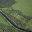
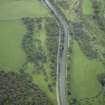
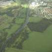
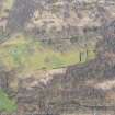
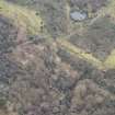
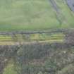
Oblique aerial view centred on the site of the Roman fortlet and the course of the Antonine Wall and the Military Way with the canal and aqueduct adjacent, taken from the WNW. |
8/9/2006 |
Item Level |
|
 |
On-line Digital Images |
DP 021006 |
RCAHMS Aerial Photography Digital |
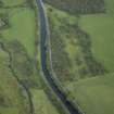
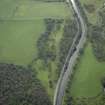
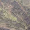
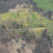
Oblique aerial view centred on the site of the Roman fortlet and the course of the Antonine Wall and the Military Way with the canal and aqueduct adjacent, taken from the W. |
8/9/2006 |
Item Level |
|
 |
On-line Digital Images |
DP 021007 |
RCAHMS Aerial Photography Digital |
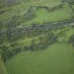
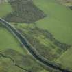
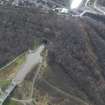
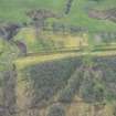
Oblique aerial view centred on the site of the Roman fortlet and the course of the Antonine Wall and the Military Way with the canal and aqueduct adjacent, taken from the S. |
8/9/2006 |
Item Level |
|
 |
On-line Digital Images |
DP 021008 |
RCAHMS Aerial Photography Digital |
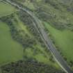
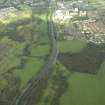
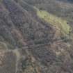
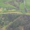
Oblique aerial view centred on the site of the Roman fortlet and the course of the Antonine Wall and the Military Way with the canal and aqueduct adjacent, taken from the E. |
8/9/2006 |
Item Level |
|
 |
On-line Digital Images |
DP 021009 |
RCAHMS Aerial Photography Digital |
Oblique aerial view centred on the site of the Roman fortlet and the course of the Antonine Wall and the Military Way with the canal and aqueduct adjacent, taken from the NE. |
8/9/2006 |
Item Level |
|
 |
On-line Digital Images |
DP 021010 |
RCAHMS Aerial Photography Digital |
Oblique aerial view centred on the site of the Roman fortlet and the course of the Antonine Wall and the Military Way with the canal and aqueduct adjacent, taken from the NE. |
8/9/2006 |
Item Level |
|
 |
On-line Digital Images |
DP 021011 |
RCAHMS Aerial Photography Digital |
Oblique aerial view centred on the site of the Roman fortlet and the course of the Antonine Wall and the Military Way with the canal and aqueduct adjacent, taken from the WNW. |
8/9/2006 |
Item Level |
|
 |
On-line Digital Images |
DP 021012 |
RCAHMS Aerial Photography Digital |
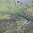
General oblique aerial view centred on the site of the Roman fortlet and the course of the Antonine Wall and the Military Way with the canal and aqueduct adjacent, taken from the SW. |
8/9/2006 |
Item Level |
|
 |
On-line Digital Images |
DP 021013 |
RCAHMS Aerial Photography Digital |
General oblique aerial view centred on the site of the Roman fortlet and the course of the Antonine Wall and the Military Way with the canal and aqueduct adjacent, taken from the SSW. |
8/9/2006 |
Item Level |
|
 |
Digital Files (Non-image) |
WP 003887 |
Publications by the Royal Commission on the Ancient and Historical Monuments of Scotland |
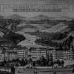
Exploring Scotland's Heritage: Clyde Estuary And Central Region |
1985 |
Item Level |
|
 |
On-line Digital Images |
DP 249504 |
Historic Environment Scotland |
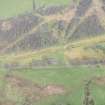
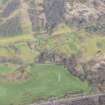
Oblique aerial view. |
24/3/2017 |
Item Level |
|
 |
On-line Digital Images |
DP 249505 |
Historic Environment Scotland |
Oblique aerial view. |
24/3/2017 |
Item Level |
|
 |
On-line Digital Images |
DP 249506 |
Historic Environment Scotland |
Oblique aerial view. |
24/3/2017 |
Item Level |
|
 |
On-line Digital Images |
DP 249507 |
Historic Environment Scotland |
Oblique aerial view. |
24/3/2017 |
Item Level |
|
 |
On-line Digital Images |
DP 249510 |
Historic Environment Scotland |
Oblique aerial view. |
24/3/2017 |
Item Level |
|
 |
On-line Digital Images |
DP 249511 |
Historic Environment Scotland |
Oblique aerial view. |
24/3/2017 |
Item Level |
|
 |
On-line Digital Images |
DP 249512 |
Historic Environment Scotland |
Oblique aerial view. |
24/3/2017 |
Item Level |
|
 |
On-line Digital Images |
DP 249513 |
Historic Environment Scotland |
Oblique aerial view. |
24/3/2017 |
Item Level |
|
 |
On-line Digital Images |
DP 249514 |
Historic Environment Scotland |
Oblique aerial view. |
24/3/2017 |
Item Level |
|
 |
On-line Digital Images |
DP 249515 |
Historic Environment Scotland |
Oblique aerial view. |
24/3/2017 |
Item Level |
|
 |
On-line Digital Images |
DP 249516 |
Historic Environment Scotland |
Oblique aerial view. |
24/3/2017 |
Item Level |
|
 |
On-line Digital Images |
DP 249517 |
Historic Environment Scotland |
Oblique aerial view. |
24/3/2017 |
Item Level |
|


