 |
On-line Digital Images |
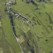
DP 018016 |
RCAHMS Aerial Photography Digital |
Oblique aerial view centred on the church and burial ground with the remains of the township adjacent, taken from the SW. |
27/6/2006 |
Item Level |
|
 |
On-line Digital Images |
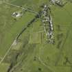
DP 018017 |
RCAHMS Aerial Photography Digital |
Oblique aerial view centred on the church and burial ground with the remains of the township adjacent, taken from the SSW. |
27/6/2006 |
Item Level |
|
 |
On-line Digital Images |
SC 2383528 |
Records of the Ordnance Survey, Southampton, Hampshire, England |
Seil, Kilbrandon, NM71NE 2, Ordnance Survey index card, Recto |
c. 1958 |
Item Level |
|
 |
On-line Digital Images |
SC 2383529 |
Records of the Ordnance Survey, Southampton, Hampshire, England |
Seil, Kilbrandon, NM71NE 2, Ordnance Survey index card, page number 1, Recto |
c. 1958 |
Item Level |
|
 |
On-line Digital Images |
SC 2383530 |
Records of the Ordnance Survey, Southampton, Hampshire, England |
Seil, Kilbrandon, NM71NE 2, Ordnance Survey index card, page number 2, Verso |
c. 1958 |
Item Level |
|


