 |
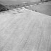
On-line Digital Images |
SC 1011139 |
Records of Aberdeen Aerial Surveys, Aberdeen, Scotland |
Oblique aerial view centred on the cropmarks of the ring ditches, possible unenclosed settlement and pits at Bogenjohn, looking to the N. |
1977 |
Item Level |
|
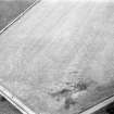 |
On-line Digital Images |
SC 1011142 |
Records of Aberdeen Aerial Surveys, Aberdeen, Scotland |
Oblique aerial view centred on the cropmarks of the ring ditches, possible unenclosed settlement and pits at Bogenjohn, looking to the S. |
1977 |
Item Level |
|
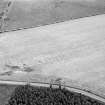 |
On-line Digital Images |
SC 1011143 |
Records of Aberdeen Aerial Surveys, Aberdeen, Scotland |
Oblique aerial view centred on the cropmarks of the ring ditches, possible unenclosed settlement and pits at Bogenjohn, looking to the ESE. |
1977 |
Item Level |
|
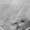 |
On-line Digital Images |
SC 2006340 |
Records of Aberdeen Aerial Surveys, Aberdeen, Scotland |
Aerial photograph |
1977 |
Item Level |
|
 |
On-line Digital Images |
SC 2379437 |
Records of the Ordnance Survey, Southampton, Hampshire, England |
Bogenjohn, NJ95SW 18, Ordnance Survey index card, Recto |
c. 1958 |
Item Level |
|


