 |
On-line Digital Images |
SC 681541 |
Records of the Society of Antiquaries of Scotland, Edinburgh, Scotland |
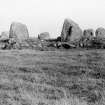
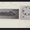
General view of circle. |
1908 |
Item Level |
|
 |
On-line Digital Images |
SC 1097320 |
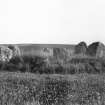
Angus Graham |
Circle at Ythsie. Diameter 24ft. Stones about 4.5ft high |
c. 1930 |
Item Level |
|
 |
On-line Digital Images |
SC 1303857 |
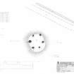
Records of the Royal Commission on the Ancient and Historical Monuments of Scotland (RCAHMS), Edinbu |
RCAHMS survey drawing: Plan, elevation and sections of South Ythsie cairn |
16/5/2005 |
Item Level |
|
 |
On-line Digital Images |
SC 1556026 |
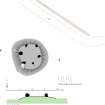
Historic Environment Scotland |
HES Survey and Recording Illustration: Plan and section of South Ythsie. |
11/2016 |
Item Level |
|
 |
On-line Digital Images |
SC 2377707 |
Records of the Ordnance Survey, Southampton, Hampshire, England |
South Ythsie, NJ83SE 12, Ordnance Survey index card, page number 1, Recto |
c. 1958 |
Item Level |
|
 |
On-line Digital Images |
SC 2377708 |
Records of the Ordnance Survey, Southampton, Hampshire, England |
South Ythsie, NJ83SE 12, Ordnance Survey index card, Recto |
c. 1958 |
Item Level |
|
 |
On-line Digital Images |
SC 2377709 |
Records of the Ordnance Survey, Southampton, Hampshire, England |
South Ythsie, NJ83SE 12, Ordnance Survey index card, Recto |
c. 1958 |
Item Level |
|
 |
On-line Digital Images |
SC 2377710 |
Records of the Ordnance Survey, Southampton, Hampshire, England |
South Ythsie, NJ83SE 12, Ordnance Survey index card, Recto |
c. 1958 |
Item Level |
|


