 |
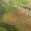
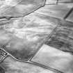
On-line Digital Images |
DP 046389 |
RCAHMS Aerial Photography Digital |
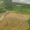
Oblique aerial view looking across the cropmarks of the trackway, possible enclosure and frost wedges towards Machir Bay, taken from the NE. |
5/8/2008 |
Item Level |
|
 |
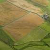
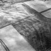
On-line Digital Images |
DP 046390 |
RCAHMS Aerial Photography Digital |
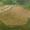
Oblique aerial view of the cropmarks of the trackway, possible enclosure and pits, taken from the NNE. |
5/8/2008 |
Item Level |
|
 |
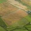
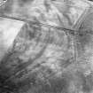
On-line Digital Images |
DP 046391 |
RCAHMS Aerial Photography Digital |
Oblique aerial view of the cropmarks of the trackway, possible enclosure and pits, taken from the NNE. |
5/8/2008 |
Item Level |
|
 |
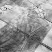
On-line Digital Images |
DP 046392 |
RCAHMS Aerial Photography Digital |
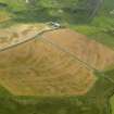
Oblique aerial view of the cropmarks of the trackway, possible enclosure and pits, taken from the NW. |
5/8/2008 |
Item Level |
|
 |
On-line Digital Images |
DP 046393 |
RCAHMS Aerial Photography Digital |
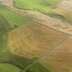
Oblique aerial view of the cropmarks of the trackway, possible enclosure and pits, taken from the WNW. |
5/8/2008 |
Item Level |
|
 |
On-line Digital Images |
DP 046394 |
RCAHMS Aerial Photography Digital |
Oblique aerial view of the cropmarks of the trackway, possible enclosure and pits, taken from the W. |
5/8/2008 |
Item Level |
|
 |
On-line Digital Images |
DP 046395 |
RCAHMS Aerial Photography Digital |
Oblique aerial view of the cropmarks of the trackway, possible enclosure and pits, taken from the W. |
5/8/2008 |
Item Level |
|
 |
On-line Digital Images |
SC 1723639 |
RCAHMS Aerial Photography |
Oblique aerial photograph of Machrie, Islay, taken from the SE. |
17/7/1997 |
Item Level |
|
 |
On-line Digital Images |
SC 1723640 |
RCAHMS Aerial Photography |
Oblique aerial photograph of Machrie, Islay, taken from the ESE. |
17/7/1997 |
Item Level |
|
 |
On-line Digital Images |
SC 1723641 |
RCAHMS Aerial Photography |
Oblique aerial photograph of Machrie, Islay, taken from the E. |
17/7/1997 |
Item Level |
|
 |
On-line Digital Images |
SC 1723642 |
RCAHMS Aerial Photography |
Oblique aerial photograph of Machrie, Islay, taken from the NE. |
17/7/1997 |
Item Level |
|
 |
On-line Digital Images |
SC 1723643 |
RCAHMS Aerial Photography |
Oblique aerial photograph of Machrie, Islay, taken from the ENE. |
17/7/1997 |
Item Level |
|


