 |
On-line Digital Images |
DP 106297 |
Scotland's Rural Past |
Logan Burn: building (Hare Hill House) viewed from N side of valley |
27/2/2011 |
Item Level |
|
 |
On-line Digital Images |
DP 106298 |
Scotland's Rural Past |
Logan Burn: building (Hare Hill House) viewed from SW (photographed by Robin Murdoch) |
24/3/2007 |
Item Level |
|
 |
On-line Digital Images |
DP 106299 |
Scotland's Rural Past |
Logan Burn: building (Hare Hill House) viewed from NW (photographed by Robin Murdoch) |
24/3/2007 |
Item Level |
|
 |
On-line Digital Images |
DP 106300 |
Scotland's Rural Past |
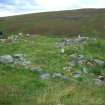
Logan Burn: building (Hare Hill House) viewed from S showing terrace on S side of building |
20/7/2008 |
Item Level |
|
 |
On-line Digital Images |
DP 106301 |
Scotland's Rural Past |
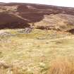
Logan Burn: enclosure and access track viewed from N |
27/2/2011 |
Item Level |
|
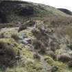 |
On-line Digital Images |
DP 106302 |
Scotland's Rural Past |
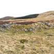
Logan Burn: enclosure wall viewed from W |
22/4/2008 |
Item Level |
|
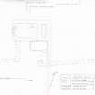 |
On-line Digital Images |
SC 1248665 |
Scotland's Rural Past |
Measured survey of Hare Hill House, Logan Burn drawn at 1:100 |
28/2/2011 |
Item Level |
|
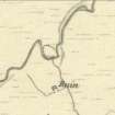 |
On-line Digital Images |
SC 1248666 |
Scotland's Rural Past |
Logan Burn as depicted on the 1st Edition of the Ordnance Survey 6-inch map (Edinburghshire 1853, sheet 11) |
9/2011 |
Item Level |
|
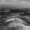 |
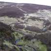
On-line Digital Images |
SC 1315241 |
Records of Aerofilms Ltd, aerial photographers, Bristol, England |
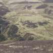
Pentland Hills, general view, showing Logan Burn and Black Hill. Oblique aerial photograph taken facing north-east. This image has been produced from a print. |
17/4/1951 |
Item Level |
|


