 |
On-line Digital Images |
SC 791237 |
Papers of Professor John R Hume, economic and industrial historian, Glasgow, Scotland |
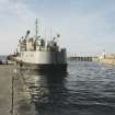
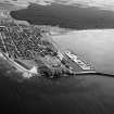
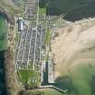
View from NE showing dredger ship dredging harbour |
1979 |
Item Level |
|
|
Photographs and Off-line Digital Images |
D 15500 P |
|
Photographic copy of drawing showing site plan. |
1838 |
Item Level |
|
 |
On-line Digital Images |
SC 1012397 |
Records of Aberdeen Aerial Surveys, Aberdeen, Scotland |
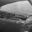
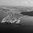
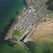
Oblique aerial view centred on the town and harbour of Burghead, looking to the SSE. |
24/8/1979 |
Item Level |
|
 |
On-line Digital Images |
SC 1012400 |
Records of Aberdeen Aerial Surveys, Aberdeen, Scotland |
Oblique aerial view centred on the town and harbour of Burghead, looking to the SSE. |
24/8/1979 |
Item Level |
|
 |
On-line Digital Images |
SC 1012403 |
Records of Aberdeen Aerial Surveys, Aberdeen, Scotland |
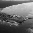
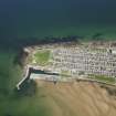
Oblique aerial view centred on the town and harbour of Burghead, looking to the SE. |
24/8/1979 |
Item Level |
|
 |
On-line Digital Images |
SC 1012404 |
Records of Aberdeen Aerial Surveys, Aberdeen, Scotland |
Oblique aerial view centred on the town and harbour of Burghead, looking to the SE. |
24/8/1979 |
Item Level |
|
 |
On-line Digital Images |
SC 1012405 |
Records of Aberdeen Aerial Surveys, Aberdeen, Scotland |
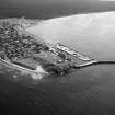
Oblique aerial view centred on the town and harbour of Burghead, looking to the E. |
24/8/1979 |
Item Level |
|
 |
On-line Digital Images |
DP 018083 |
General Collection |
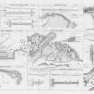
Engraving of elevation and plan inscr: ''Plans and Dimensions of Harbours, Wharfs and Ferry-Piers made or improved under the direction of the Commissioner for Highland Roads and Bridges, 1806-1821.'' |
1838 |
Item Level |
|
 |
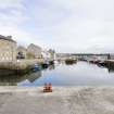
On-line Digital Images |
DP 079126 |
RCAHMS Field Survey Digital Photography |
View from NE showing Telford House and North Pier. |
5/5/2010 |
Item Level |
|
 |
On-line Digital Images |
DP 079127 |
RCAHMS Field Survey Digital Photography |
View from NE showing North Pier. |
5/5/2010 |
Item Level |
|
 |
On-line Digital Images |
DP 079128 |
RCAHMS Field Survey Digital Photography |
View from NW showing North Quay, Telford House, warehouse and South Pier. |
5/5/2010 |
Item Level |
|
 |
On-line Digital Images |
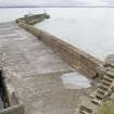
DP 079129 |
RCAHMS Field Survey Digital Photography |
View from N showing North Pier. |
5/5/2010 |
Item Level |
|
 |
On-line Digital Images |
DP 079130 |
RCAHMS Field Survey Digital Photography |
View from NNW showing South Pier. |
5/5/2010 |
Item Level |
|
 |
On-line Digital Images |
DP 079131 |
RCAHMS Field Survey Digital Photography |
Detail of harbour wall on North Pier. |
5/5/2010 |
Item Level |
|
 |
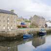
On-line Digital Images |
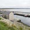
DP 079132 |
RCAHMS Field Survey Digital Photography |
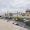
View from W showing North Quay and Telford House, warehouse. |
5/5/2010 |
Item Level |
|
 |
On-line Digital Images |
DP 079133 |
RCAHMS Field Survey Digital Photography |
View from WSW showing North Quay and Telford House warehouse. |
5/5/2010 |
Item Level |
|
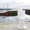 |
On-line Digital Images |
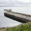
DP 079134 |
RCAHMS Field Survey Digital Photography |
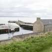
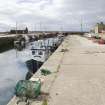
View from NE showing the entrance to the harbour. |
5/5/2010 |
Item Level |
|
 |
On-line Digital Images |
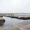
DP 079135 |
RCAHMS Field Survey Digital Photography |
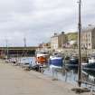
View from E showing North and S piers with harbour. |
5/5/2010 |
Item Level |
|
 |
On-line Digital Images |
DP 079136 |
RCAHMS Field Survey Digital Photography |
View from SE from S pier looking to North Pier and the warehouses. |
5/5/2010 |
Item Level |
|
 |
On-line Digital Images |
DP 079137 |
RCAHMS Field Survey Digital Photography |
View from SE of harbour and part of North Pier and two warehouses. |
5/5/2010 |
Item Level |
|
 |
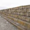
On-line Digital Images |
DP 079138 |
RCAHMS Field Survey Digital Photography |
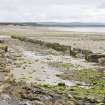
View from N showing re-used anti-tank blocks/cubes immediately S of the caravan park at Burghead. |
5/5/2010 |
Item Level |
|
 |
On-line Digital Images |
DP 103343 |
RCAHMS Aerial Photography Digital |
General oblique aerial view of Burghead, centred on the harbour, taken from the WNW. |
26/4/2011 |
Item Level |
|
 |
On-line Digital Images |
DP 103344 |
RCAHMS Aerial Photography Digital |
General oblique aerial view of Burghead, centred on the harbour, taken from the W. |
26/4/2011 |
Item Level |
|
 |
On-line Digital Images |
DP 103345 |
RCAHMS Aerial Photography Digital |
General oblique aerial view of Burghead, centred on the harbour, taken from the SSW. |
26/4/2011 |
Item Level |
|


