 |
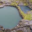
On-line Digital Images |
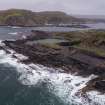
DP 264567 |
Historic Environment Scotland |
Oblique aerial view from west of Windmill Quarry (left) and Hill Quarry (right) |
4/10/2017 |
Item Level |
|
 |
On-line Digital Images |
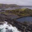
DP 264568 |
Historic Environment Scotland |
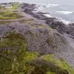
Oblique aerial view of north spoil, walls and workings from west |
4/10/2017 |
Item Level |
|
 |
On-line Digital Images |
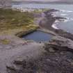
DP 264569 |
Historic Environment Scotland |
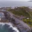
Oblique aerial view of west end of island from west. |
4/10/2017 |
Item Level |
|
 |
On-line Digital Images |
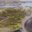
DP 264570 |
Historic Environment Scotland |
Oblique aerial view from north west |
4/10/2017 |
Item Level |
|
 |
On-line Digital Images |
DP 264571 |
Historic Environment Scotland |
Oblique aerial view from south |
4/10/2017 |
Item Level |
|
 |
On-line Digital Images |
DP 264572 |
Historic Environment Scotland |
Oblique aerial view from south west |
4/10/2017 |
Item Level |
|
 |
On-line Digital Images |
DP 264584 |
Historic Environment Scotland |
Oblique aerial view of south side of island |
4/10/2017 |
Item Level |
|
 |
On-line Digital Images |
DP 264587 |
Historic Environment Scotland |
Oblique aerial view from west of south east part of island |
4/10/2017 |
Item Level |
|
 |
On-line Digital Images |
DP 264588 |
Historic Environment Scotland |
Oblique aerial view from west of area around waste tip/bing showing earlier quarrying in the area known as Camas Mor and the eastern edge of the south west spoil, walls and workings |
4/10/2017 |
Item Level |
|
 |
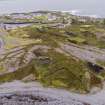
On-line Digital Images |
DP 264592 |
Historic Environment Scotland |
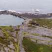
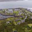
Oblique aerial view from west of Midd Engine and East Engine Quarries, Easdale village, central spoil, walls and workings and Harbour |
4/10/2017 |
Item Level |
|
 |
On-line Digital Images |
DP 264593 |
Historic Environment Scotland |
Oblique aerial view from north west with Windmill and Hill Quarries in foreground |
4/10/2017 |
Item Level |
|
 |
On-line Digital Images |
DP 264594 |
Historic Environment Scotland |
Oblique aerial view of Windmill, Hill Quarries and coastal quarrying |
4/10/2017 |
Item Level |
|
 |
On-line Digital Images |
DP 264595 |
Historic Environment Scotland |
Oblique aerial view from south west of early north west coastal quarrying adjacent to Windmill and Hill Quarries. |
4/10/2017 |
Item Level |
|
 |
On-line Digital Images |
DP 264596 |
Historic Environment Scotland |
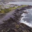
Oblique aerial view of west coastal coastal and deep quarrying |
4/10/2017 |
Item Level |
|
 |
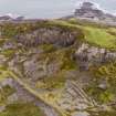
On-line Digital Images |
DP 264597 |
Historic Environment Scotland |
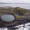
Oblique aerial view of Fang Quarry and landscape |
4/10/2017 |
Item Level |
|
 |
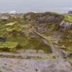
On-line Digital Images |
DP 264598 |
Historic Environment Scotland |
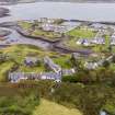
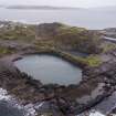
Oblique aerial view from south west of south west spoil, walls and workings landscape, Fang Quarry and An Lub Chlear Quarry, village and Harbour |
4/10/2017 |
Item Level |
|
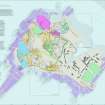 |
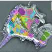
On-line Digital Images |
SC 2175746 |
Records of the Royal Commission on the Ancient and Historical Monuments of Scotland (RCAHMS), Edinbu |
Scanned copy of GV008644. Map of Easdale Island showing the mapping and phasing of the HES survey, quarrying activity, tipping, internal transport and garden enclosures. |
10/2019 |
Item Level |
|
 |
Digital Files (Non-image) |
WP 007584 |
Records of the Royal Commission on the Ancient and Historical Monuments of Scotland (RCAHMS), Edinbu |
Layered interactive PDF of Easdale Island showing the mapping and phasing of the HES survey, quarrying activity, tipping, internal transport and garden enclosures. |
10/2019 |
Item Level |
|
|
Digital Files (Non-image) |
GV 008644 |
Records of the Royal Commission on the Ancient and Historical Monuments of Scotland (RCAHMS), Edinbu |
Map of Easdale Island showing the mapping and phasing of the HES survey, quarrying activity, tipping, internal transport and garden enclosures. |
10/2019 |
Item Level |
|
 |
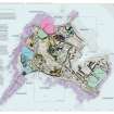
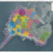
On-line Digital Images |
SC 2176606 |
Records of the Royal Commission on the Ancient and Historical Monuments of Scotland (RCAHMS), Edinbu |
Scanned copy of GV008648. Map of north-east corner of Easdale Island showing HES survey, including North spoil, walls and workings. |
10/2019 |
Item Level |
|
 |
Digital Files (Non-image) |
WP 007585 |
Records of the Royal Commission on the Ancient and Historical Monuments of Scotland (RCAHMS), Edinbu |
Layered interactive PDF map of north-east corner of Easdale Island showing HES survey, including North spoil, walls and workings. |
10/2019 |
Item Level |
|
|
Digital Files (Non-image) |
GV 008648 |
Records of the Royal Commission on the Ancient and Historical Monuments of Scotland (RCAHMS), Edinbu |
Map of north-east corner of Easdale Island showing HES survey, including North spoil, walls and workings. |
10/2019 |
Item Level |
|
 |
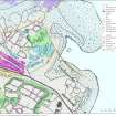
On-line Digital Images |
SC 2176656 |
Records of the Royal Commission on the Ancient and Historical Monuments of Scotland (RCAHMS), Edinbu |
Scanned copy of GV008650. Map of Easdale Island showing HES phasing survey |
10/2019 |
Item Level |
|
 |
Digital Files (Non-image) |
WP 007586 |
Records of the Royal Commission on the Ancient and Historical Monuments of Scotland (RCAHMS), Edinbu |
Layered interactive PDF map of Easdale Island showing HES phasing survey |
10/2019 |
Item Level |
|


