 |
On-line Digital Images |
SC 503736 |
|
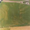
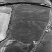
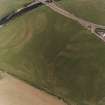
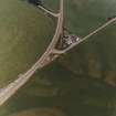
Ballantrae Bridge, oblique aerial view, taken from the SW, centred on the cropmarks of field boundaries and linear cropmarks, and on areas with pits. A possible souterrain and a round house are shown in the upper right-hand corner of the photograph. |
|
Item Level |
|
 |
On-line Digital Images |
SC 1754712 |
RCAHMS Aerial Photography |
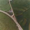
Ballantrae Bridge, oblique aerial view, taken from the SW, centred on the cropmarks of field boundaries and areas with pits. A souterrain and a round house are visible in the top right-hand corner of the photograph, and Ballantrae Bridge is shown in the top left-hand corner. |
29/6/1995 |
Item Level |
|
 |
On-line Digital Images |
SC 1754713 |
RCAHMS Aerial Photography |
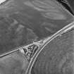
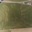
Ballantrae Bridge, Garleffin, oblique aerial view, taken from the SW, centred on the cropmarks of a barrow and four poster stone-circle, and on an area with pits. Two possible souterrains, linear cropmarks, possible enclosures and various other cropmarks are also visible in the photograph. |
29/6/1995 |
Item Level |
|
 |
On-line Digital Images |
SC 1754714 |
RCAHMS Aerial Photography |
Ballantrae Bridge, oblique aerial view, taken from the S, centred on the cropmarks of a barrow and four poster stone-circle, and on an area with pits, field boundaries and linear cropmarks. Two possible souterrains, possible enclosures and various other cropmarks are also visible in the photograph. |
29/6/1995 |
Item Level |
|
 |
On-line Digital Images |
SC 1754715 |
RCAHMS Aerial Photography |
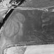
Ballantrae Bridge; Garleffin, oblique aerial view, taken from the SE, showing the cropmarks of a four poster stone-circle and a barrow in the bottom centre of the photograph. An area with pits and two possible souterrains, a round house, enclosures and linear cropmarks are visible in the centre, and field boundaries are shown in the upper half of the photograph. |
29/6/1995 |
Item Level |
|
 |
On-line Digital Images |
SC 1754718 |
RCAHMS Aerial Photography |
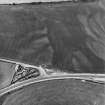
Ballantrae Bridge, oblique aerial view, taken from the E, showing the cropmarks of field boundaries, a possible souterrain and round house, and an area with pits. |
29/6/1995 |
Item Level |
|
 |
On-line Digital Images |
SC 1754719 |
RCAHMS Aerial Photography |
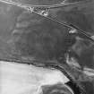
Ballantrae Bridge, oblique aerial view, taken from the NE, showing the cropmarks of field boundaries, a possible souterrain and round house, possible enclosures and an area with pits. |
29/6/1995 |
Item Level |
|
 |
On-line Digital Images |
SC 1754720 |
RCAHMS Aerial Photography |
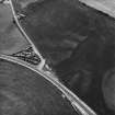
Ballantrae Bridge, oblique aerial view, taken from the NE, showing the cropmarks of field boundaries, two possible souterrains and enclosures, a round house and an area with pits. |
29/6/1995 |
Item Level |
|
 |
On-line Digital Images |
SC 1754721 |
RCAHMS Aerial Photography |
Ballantrae Bridge, oblique aerial view, taken from the NW, centred on the cropmarks of a possible souterrain and a round house. An area with pits and field boundaries are also shown in the photograph. |
29/6/1995 |
Item Level |
|
 |
On-line Digital Images |
SC 1754724 |
RCAHMS Aerial Photography |
Ballantrae Bridge, oblique aerial view, taken from the SW, centred on the cropmarks of field boundaries and linear cropmarks, and on areas with pits. A possible souterrain and a round house are shown in the upper right-hand corner of the photograph. |
29/6/1995 |
Item Level |
|
 |
On-line Digital Images |
SC 1754725 |
RCAHMS Aerial Photography |
Ballantrae Bridge, oblique aerial view, taken from the SW, centred on the cropmarks of field boundaries and linear cropmarks, and on areas with pits. A possible souterrain and a round house are shown in the upper right-hand corner of the photograph, and cropmarks of possible enclosures and souterrain are shown in the bottom right-hand corner. |
29/6/1995 |
Item Level |
|
 |
On-line Digital Images |
SC 1754726 |
RCAHMS Aerial Photography |
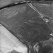
Ballantrae Bridge, oblique aerial view, taken from the N, centred on the cropmarks of a possible souterrain, a round house and pits. An area with pits is visible in the upper right-hand corner of the photograph. |
29/6/1995 |
Item Level |
|
 |
On-line Digital Images |
SC 1754727 |
RCAHMS Aerial Photography |
Ballantrae Bridge, oblique aerial view, taken from the NW, centred on the cropmarks of a possible souterrain, a round house and pits. An area with pits, field boundaries and linear cropmarks are visible in the bottom right-hand corner of the photograph. |
29/6/1995 |
Item Level |
|
 |
On-line Digital Images |
DP 281540 |
Historic Environment Scotland |
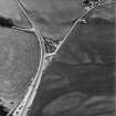
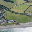
Oblique aerial view. |
16/7/2018 |
Item Level |
|


