 |
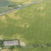
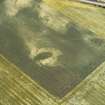
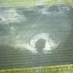
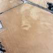
On-line Digital Images |
DP 163052 |
RCAHMS Aerial Photography Digital |
Oblique aerial view of the cropmarks of the enclosures, round houses, ditches and pits, looking SE. |
19/7/2013 |
Item Level |
|
 |
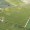
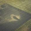
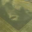
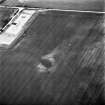
On-line Digital Images |
DP 163057 |
RCAHMS Aerial Photography Digital |
Oblique aerial view of the cropmarks of the settlement enclosure and the field boundaries, looking E. |
19/7/2013 |
Item Level |
|
 |
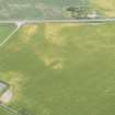
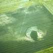
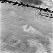
On-line Digital Images |
DP 163058 |
RCAHMS Aerial Photography Digital |
Oblique aerial view of the cropmarks of the settlement enclosure and the field boundaries, looking E. |
19/7/2013 |
Item Level |
|
 |
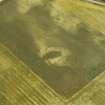
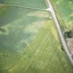
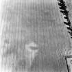
On-line Digital Images |
DP 163059 |
RCAHMS Aerial Photography Digital |
Oblique aerial view of the cropmarks of the settlement enclosure and the field boundaries, looking ENE. |
19/7/2013 |
Item Level |
|
 |
On-line Digital Images |
DP 166619 |
RCAHMS Aerial Photography Digital |
Oblique aerial view of the cropmarks of the settlement, ring ditch and pits, looking NNE. |
14/7/2013 |
Item Level |
|
 |
On-line Digital Images |
DP 166620 |
RCAHMS Aerial Photography Digital |
Oblique aerial view of the cropmarks of the settlement, ring ditch and pits, looking N. |
14/7/2013 |
Item Level |
|
 |
On-line Digital Images |
DP 166621 |
RCAHMS Aerial Photography Digital |
Oblique aerial view of the cropmarks of the settlement, ring ditch and pits, looking NNW. |
14/7/2013 |
Item Level |
|
 |
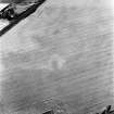
On-line Digital Images |
SC 1550590 |
Papers of Professor Geraint Dyfed Barri Jones, archaeologist, Manchester, England |
Oblique aerial view |
8/7/1988 |
Item Level |
|
 |
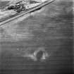
On-line Digital Images |
SC 1550591 |
Papers of Professor Geraint Dyfed Barri Jones, archaeologist, Manchester, England |
Oblique aerial view |
8/7/1988 |
Item Level |
|
 |
On-line Digital Images |
SC 1550593 |
Papers of Professor Geraint Dyfed Barri Jones, archaeologist, Manchester, England |
Oblique aerial view |
8/7/1988 |
Item Level |
|
 |
On-line Digital Images |
SC 1550594 |
Papers of Professor Geraint Dyfed Barri Jones, archaeologist, Manchester, England |
Oblique aerial view |
8/7/1988 |
Item Level |
|
 |
On-line Digital Images |
SC 1550595 |
Papers of Professor Geraint Dyfed Barri Jones, archaeologist, Manchester, England |
Oblique aerial view |
8/7/1988 |
Item Level |
|
 |
On-line Digital Images |
SC 1551130 |
Papers of Professor Geraint Dyfed Barri Jones, archaeologist, Manchester, England |
Oblique aerial view |
1988 |
Item Level |
|
 |
On-line Digital Images |
SC 1555211 |
Papers of Professor Geraint Dyfed Barri Jones, archaeologist, Manchester, England |
Oblique aerial view |
8/7/1988 |
Item Level |
|
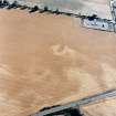 |
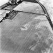
On-line Digital Images |
SC 1695969 |
RCAHMS Aerial Photography |
Allanfearn, oblique aerial view, taken from the NE, centred on cropmarks, including an enclosure and a pit-setting. |
10/8/1995 |
Item Level |
|
 |
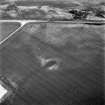
On-line Digital Images |
SC 1695975 |
RCAHMS Aerial Photography |
Allanfearn, oblique aerial view, taken from the ENE, centred on cropmarks, including an enclosure and a pit-setting. |
10/8/1995 |
Item Level |
|
 |
On-line Digital Images |
SC 1695976 |
RCAHMS Aerial Photography |
Allanfearn, oblique aerial view, taken from the SE, centred on cropmarks, including an enclosure and a pit-setting. |
10/8/1995 |
Item Level |
|
 |
On-line Digital Images |
SC 1695977 |
RCAHMS Aerial Photography |
Oblique aerial view. |
1992 |
Item Level |
|
 |
On-line Digital Images |
SC 1695978 |
RCAHMS Aerial Photography |
Allanfearn, oblique aerial view, taken from the NNE, centred on cropmarks, including an enclosure and a pit-setting. |
10/8/1995 |
Item Level |
|
 |
On-line Digital Images |
SC 1695979 |
RCAHMS Aerial Photography |
Allanfearn, oblique aerial view, taken from the NW, centred on cropmarks, including an enclosure and a pit-setting. |
10/8/1995 |
Item Level |
|
 |
On-line Digital Images |
SC 1695980 |
|
Allanfearn, oblique aerial view, taken from the SW, centred on cropmarks, including an enclosure and a pit-setting. |
10/8/1995 |
Item Level |
|
 |
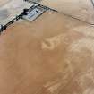
On-line Digital Images |
SC 1695981 |
RCAHMS Aerial Photography |
Allanfearn, oblique aerial view, taken from the ESE, centred on cropmarks, including an enclosure and a pit-setting. Allanfearn Farm is visible in the top left-hand corner of the photograph. |
10/8/1995 |
Item Level |
|
 |
On-line Digital Images |
SC 1696000 |
RCAHMS Aerial Photography |
Oblique aerial view. |
1992 |
Item Level |
|
 |
On-line Digital Images |
SC 1696001 |
RCAHMS Aerial Photography |
Oblique aerial view. |
1992 |
Item Level |
|


