 |
On-line Digital Images |
SC 923672 |
Records of the Royal Commission on the Ancient and Historical Monuments of Scotland (RCAHMS), Edinbu |
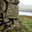
Detail of S corner of building (BL00 733) within township, showing cupmarks on quoin. View from W. |
c. 2001 |
Item Level |
|
 |
On-line Digital Images |
SC 923673 |
Records of the Royal Commission on the Ancient and Historical Monuments of Scotland (RCAHMS), Edinbu |
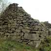
SW gable of building (BL00 733) within township. There are cupmarks on the two lower quoins in the S corner (in foreground). |
c. 2001 |
Item Level |
|
 |
On-line Digital Images |
SC 926214 |
RCAHMS Aerial Photography |
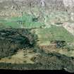
Oblique aerial view of the landscape, field systems and farmsteads on the farms of Carie and Tombreck, Lochtayside. Taken from SE. |
18/2/2004 |
Item Level |
|
 |
On-line Digital Images |
SC 926232 |
Records of the Royal Commission on the Ancient and Historical Monuments of Scotland (RCAHMS), Edinbu |
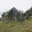
Ruined byre dwelling (BL00 738), showing fragment of possible laird's house incorporated into the NE gable. View from NNE. |
4/2002 |
Item Level |
|


