 |
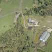
On-line Digital Images |
DP 211561 |
RCAHMS Aerial Photography Digital |
Oblique aerial view of the long cairns at Kinrive, looking NNE. |
14/5/2015 |
Item Level |
|
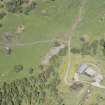 |
On-line Digital Images |
DP 211562 |
RCAHMS Aerial Photography Digital |
Oblique aerial view of the long cairns at Kinrive, looking NNE. |
14/5/2015 |
Item Level |
|
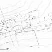 |
On-line Digital Images |
SC 1817244 |
Records of the Royal Commission on the Ancient and Historical Monuments of Scotland (RCAHMS), Edinbu |
Publication drawing; site plan of Kinrive, showing the position of the chambered cairns, hut circles and field system. Scanned copy. |
1979 |
Item Level |
|
 |
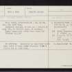
On-line Digital Images |
SC 2364743 |
Records of the Ordnance Survey, Southampton, Hampshire, England |
Kinrive East, NH67NE 5, Ordnance Survey index card, Recto |
1958 |
Item Level |
|
 |
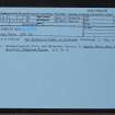
On-line Digital Images |
SC 2364744 |
Records of the Ordnance Survey, Southampton, Hampshire, England |
Kinrive East, NH67NE 5, Ordnance Survey index card, Recto |
1958 |
Item Level |
|
 |
On-line Digital Images |
SC 2364745 |
Records of the Ordnance Survey, Southampton, Hampshire, England |
Kinrive East, NH67NE 5, Ordnance Survey index card, Recto |
1958 |
Item Level |
|


