 |
On-line Digital Images |
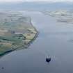
DP 093478 |
RCAHMS Aerial Photography Digital |
General oblique aerial view of the Cromarty Firth, looking SW. |
24/7/2010 |
Item Level |
|
 |
On-line Digital Images |
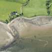
DP 191575 |
RCAHMS Aerial Photography Digital |
Oblique aerial view of the fish trap and Ferryton Point, looking SSE. |
18/6/2014 |
Item Level |
|
 |
On-line Digital Images |
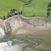
DP 191576 |
RCAHMS Aerial Photography Digital |
Oblique aerial view of the fish trap and Ferryton Point, looking SSE. |
18/6/2014 |
Item Level |
|
 |
On-line Digital Images |
SC 2364586 |
Records of the Ordnance Survey, Southampton, Hampshire, England |
Ferryton Point, NH66NE 38, Ordnance Survey index card, Recto |
1958 |
Item Level |
|


