 |
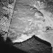
On-line Digital Images |
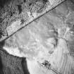
SC 1716193 |
RCAHMS Aerial Photography |
Oblique aerial view centred on the remains of a township and rig with hut-circles and field banks adjacent, taken from the SSE. |
16/11/1998 |
Item Level |
|
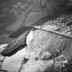 |
On-line Digital Images |
SC 1716196 |
RCAHMS Aerial Photography |
Oblique aerial view centred on the remains of a township and rig, taken from the ESE. |
16/11/1998 |
Item Level |
|
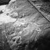 |
On-line Digital Images |
SC 1716197 |
RCAHMS Aerial Photography |
Oblique aerial view centred on the remains of hut-circles and field banks with township and rig adjacent, taken from the ENE. |
16/11/1998 |
Item Level |
|
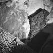 |
On-line Digital Images |
SC 1716198 |
RCAHMS Aerial Photography |
Oblique aerial view centred on the remains of a township with rig adjacent, taken from the W. |
16/11/1998 |
Item Level |
|
 |
On-line Digital Images |
SC 1716199 |
RCAHMS Aerial Photography |
Oblique aerial view centred on the remains of a township with rig adjacent, taken from the SSW. |
16/11/1998 |
Item Level |
|


