 |
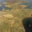
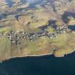
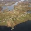
On-line Digital Images |
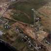
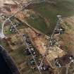
SC 1007567 |
RCAHMS Aerial Photography |
General oblique aerial view centred on the township with the burial-ground, church and township adjacent, taken from the W. |
23/4/2005 |
Item Level |
|
 |
On-line Digital Images |
SC 1007568 |
RCAHMS Aerial Photography |
General oblique aerial view centred on the township with the burial-ground and church adjacent, taken from the NW. |
23/4/2005 |
Item Level |
|
 |
On-line Digital Images |
SC 1007569 |
RCAHMS Aerial Photography |
Oblique aerial view centred on the township with the burial-ground and manse adjacent, taken from the SE. |
23/4/2005 |
Item Level |
|
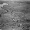 |
On-line Digital Images |
DP 048124 |
Records of Aerofilms Ltd, aerial photographers, Bristol, England |
Lewis, Crossbost township, oblique aerial view. |
16/7/1965 |
Item Level |
|
 |
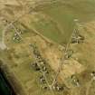
On-line Digital Images |
DP 111270 |
RCAHMS Aerial Photography Digital |
Oblique aerial view of the remains of the township, head dyke and lazy beds at Crosbost, Lochs, Lewis, taken from the SSW. |
16/11/2011 |
Item Level |
|
 |
On-line Digital Images |
DP 111271 |
RCAHMS Aerial Photography Digital |
General oblique aerial view of the townships of Crosbost, Ranish and Grimshader, looking towards Stornoway, Lewis, taken from the SSE. |
16/11/2011 |
Item Level |
|
 |
On-line Digital Images |
DP 111272 |
RCAHMS Aerial Photography Digital |
General oblique aerial view of the townships of Crosbost, Ranish and Grimshader, looking towards Stornoway, Lewis, taken from the SSE. |
16/11/2011 |
Item Level |
|
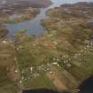 |
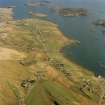
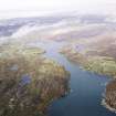
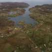
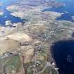
On-line Digital Images |
SC 1690856 |
RCAHMS Aerial Photography |
Oblique aerial view centred on the townships, taken from the SW. |
24/9/2004 |
Item Level |
|
 |
On-line Digital Images |
SC 1690857 |
RCAHMS Aerial Photography |
Oblique aerial view centred on the townships, taken from the SW. |
24/9/2004 |
Item Level |
|
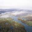 |
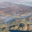
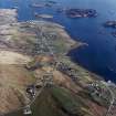
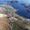
On-line Digital Images |
SC 1690869 |
RCAHMS Aerial Photography |
General oblique aerial view looking across Loch Griomsiadair and the townships towards Loch Liurboist, taken from the E. |
29/9/2004 |
Item Level |
|
 |
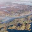
On-line Digital Images |
SC 1690870 |
RCAHMS Aerial Photography |
General oblique aerial view looking across Loch Griomsiadair and the townships towards Loch Liurboist, taken from the ENE. |
29/9/2004 |
Item Level |
|
 |
On-line Digital Images |
SC 1690871 |
RCAHMS Aerial Photography |
General oblique aerial view looking across Loch Griomsiadair and the townships towards Loch Liurboist, taken from the ENE. |
29/9/2004 |
Item Level |
|
 |
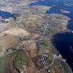
On-line Digital Images |
SC 1690927 |
RCAHMS Aerial Photography |
Oblique aerial view centred on the township with the burial-ground adjacent, taken from the SE. |
23/4/2005 |
Item Level |
|
 |
On-line Digital Images |
SC 1690928 |
RCAHMS Aerial Photography |
General oblique aerial view centred on the township with the burial-ground and church adjacent, taken from the NW. |
23/4/2005 |
Item Level |
|
 |
On-line Digital Images |
SC 1690929 |
RCAHMS Aerial Photography |
General oblique aerial view centred on the township with the burial-ground, church and cemeteries and township adjacent, taken from the WNW. |
23/4/2005 |
Item Level |
|
 |
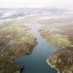
On-line Digital Images |
SC 1691064 |
RCAHMS Aerial Photography |
Oblique aerial view centred on the townships, taken from the WSW. |
24/9/2004 |
Item Level |
|
 |
On-line Digital Images |
SC 1692288 |
RCAHMS Aerial Photography |
Oblique aerial view centred on the township with the burial-ground and manse adjacent, taken from the SE. |
23/4/2005 |
Item Level |
|
 |
On-line Digital Images |
SC 1692289 |
RCAHMS Aerial Photography |
General oblique aerial view centred on the township with the burial-ground and church adjacent, taken from the NW. |
23/4/2005 |
Item Level |
|
 |
On-line Digital Images |
SC 1692290 |
RCAHMS Aerial Photography |
General oblique aerial view centred on the township with the burial-ground, church and township adjacent, taken from the W. |
23/4/2005 |
Item Level |
|


