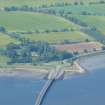
 |
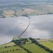
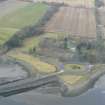
On-line Digital Images |
DP 093611 |
RCAHMS Aerial Photography Digital |
General oblique aerial view of the Cromarty Bridge with Ardullie Lodge in the foreground, looking SSE. |
24/7/2010 |
Item Level |
|
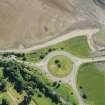 |
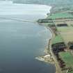
On-line Digital Images |
DP 191601 |
RCAHMS Aerial Photography Digital |
Oblique aerial view of Ardullie Point, looking E. |
18/6/2014 |
Item Level |
|
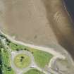 |
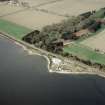
On-line Digital Images |
DP 191603 |
RCAHMS Aerial Photography Digital |
Oblique aerial view of Ardullie Point, looking ENE. |
18/6/2014 |
Item Level |
|
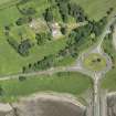 |
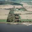
On-line Digital Images |
DP 191604 |
RCAHMS Aerial Photography Digital |
Oblique aerial view of Ardullie Point, looking NNW. |
18/6/2014 |
Item Level |
|
 |
On-line Digital Images |
SC 1945115 |
Papers of James Sloan Bone, landscape historian, Inverness, Highland, Scotland |
Aerial view of Foulis Point and Cromarty Bridge, Cromarty Firth, looking SW. |
8/5/2000 |
Item Level |
|
 |
On-line Digital Images |
SC 1945116 |
Papers of James Sloan Bone, landscape historian, Inverness, Highland, Scotland |
Aerial view of Foulis Point, Evanton, Easter Ross, looking W. |
8/5/2000 |
Item Level |
|
 |
On-line Digital Images |
SC 1945117 |
Papers of James Sloan Bone, landscape historian, Inverness, Highland, Scotland |
Aerial view of Foulis, Evanton, Easter Ross, looking NW. |
8/5/2000 |
Item Level |
|
 |
On-line Digital Images |
DP 341266 |
Papers of James Sloan Bone, landscape historian, Inverness, Highland, Scotland |
Aerial view of Ardullie Point and Ardullie House, near Evanton, Easter Ross, looking NW. |
16/3/2008 |
Item Level |
|
 |
On-line Digital Images |
DP 343664 |
Papers of James Sloan Bone, landscape historian, Inverness, Highland, Scotland |
Oblique aerial view of north end of Cromarty Bridge and farmland at Ardullie, Black Isle, looking NW. |
18/7/2018 |
Item Level |
|
 |
On-line Digital Images |
SC 2363045 |
Records of the Ordnance Survey, Southampton, Hampshire, England |
Ardullie Lodge, NH56SE 21, Ordnance Survey index card, Recto |
c. 1958 |
Item Level |
|
 |
On-line Digital Images |
SC 2363046 |
Records of the Ordnance Survey, Southampton, Hampshire, England |
Ardullie Lodge, NH56SE 21, Ordnance Survey index card, Recto |
c. 1958 |
Item Level |
|


