 |
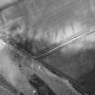
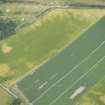
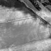
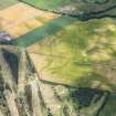
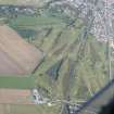
On-line Digital Images |
SC 919477 |
RCAHMS Aerial Photography |
Oblique aerial view. |
1982 |
Item Level |
|
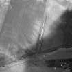 |
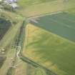
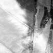
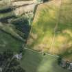
On-line Digital Images |
SC 1029401 |
RCAHMS Aerial Photography |
Oblique aerial view. |
1982 |
Item Level |
|
 |
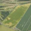
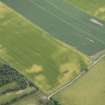
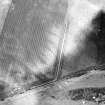
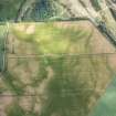
On-line Digital Images |
DP 163963 |
RCAHMS Aerial Photography Digital |
Oblique aerial view of the cropmarks of the enclosure, possible sunken floored building and pits, looking E. |
17/7/2013 |
Item Level |
|
 |
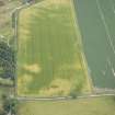
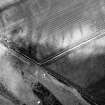
On-line Digital Images |
DP 163964 |
RCAHMS Aerial Photography Digital |
Oblique aerial view of the cropmarks of the enclosure, possible sunken floored buildings and pits, looking ESE. |
17/7/2013 |
Item Level |
|
 |
On-line Digital Images |
DP 163965 |
RCAHMS Aerial Photography Digital |
Oblique aerial view of the cropmarks of the enclosure, possible sunken floored buildings and pits, looking E. |
17/7/2013 |
Item Level |
|
 |
On-line Digital Images |
DP 163969 |
RCAHMS Aerial Photography Digital |
Oblique aerial view of the cropmarks of the roundhouse, possible sunken floored building and pits, looking S. |
17/7/2013 |
Item Level |
|
 |
On-line Digital Images |
DP 163972 |
RCAHMS Aerial Photography Digital |
Oblique aerial view of the cropmarks of the enclosure, possible sunken floored buildings and pits, looking SSE. |
17/7/2013 |
Item Level |
|
 |
On-line Digital Images |
DP 163974 |
RCAHMS Aerial Photography Digital |
Oblique aerial view of the cropmarks of the enclosure, possible sunken floored buildings and pits, looking ESE. |
17/7/2013 |
Item Level |
|
 |
On-line Digital Images |
SC 1695326 |
RCAHMS Aerial Photography |
Oblique aerial view. |
1982 |
Item Level |
|
 |
On-line Digital Images |
SC 1695327 |
RCAHMS Aerial Photography |
Oblique aerial view. |
1982 |
Item Level |
|
 |
On-line Digital Images |
SC 1695328 |
RCAHMS Aerial Photography |
Oblique aerial view. |
1982 |
Item Level |
|
 |
On-line Digital Images |
SC 1695329 |
RCAHMS Aerial Photography |
Oblique aerial view. |
1982 |
Item Level |
|
 |
On-line Digital Images |
DP 281850 |
Historic Environment Scotland |
Oblique aerial view. |
19/7/2018 |
Item Level |
|
 |
On-line Digital Images |
DP 281851 |
Historic Environment Scotland |
Oblique aerial view. |
19/7/2018 |
Item Level |
|
 |
On-line Digital Images |
DP 281852 |
Historic Environment Scotland |
Oblique aerial view. |
19/7/2018 |
Item Level |
|
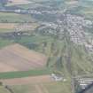 |
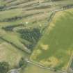
On-line Digital Images |
DP 343168 |
Papers of James Sloan Bone, landscape historian, Inverness, Highland, Scotland |
An oblique aerial view of Muir of Ord, Black Isle, looking N. |
1/10/2013 |
Item Level |
|
 |
On-line Digital Images |
DP 343169 |
Papers of James Sloan Bone, landscape historian, Inverness, Highland, Scotland |
An oblique aerial view of Muir of Ord, Black Isle, looking NNE. |
1/10/2013 |
Item Level |
|
 |
On-line Digital Images |
SC 2362522 |
Records of the Ordnance Survey, Southampton, Hampshire, England |
Ardnagrask, NH54NW 36, Ordnance Survey index card, Recto |
1958 |
Item Level |
|
 |
On-line Digital Images |
SC 2362523 |
Records of the Ordnance Survey, Southampton, Hampshire, England |
Ardnagrask, NH54NW 36, Ordnance Survey index card, Recto |
1958 |
Item Level |
|


