 |
On-line Digital Images |
DP 140195 |
General Collection |
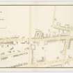
Plan of the area around Causewayside including Duncan Street, Upper Gray Street, Grange Road, Salisbury Place, Sciennes, Sciennes Place, West Preston Street, Newington Road, Summer Hall and part of the Meadows.
Insc. 'Plan of the Causewayside and its immediate neighbourhood shewing the slaughter houses at Grange Court. March 1850. Alfred Lancefield Surveyor. 11 Buccleuch Place Edinburgh.'
Insc. on the back of the drawing 'Plan of the Slaughter houses at the Causewayside Edinburgh by A Lancefield. Drawer 28 No. 28.' |
3/1850 |
Item Level |
|
 |
On-line Digital Images |
DP 218613 |
RCAHMS Aerial Photography Digital |
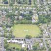
Oblique aerial view of The Lane House and Grange Road, looking E. |
24/7/2015 |
Item Level |
|
 |
On-line Digital Images |
DP 218617 |
RCAHMS Aerial Photography Digital |
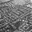
Oblique aerial view of Grange Road, looking N. |
24/7/2015 |
Item Level |
|
 |
On-line Digital Images |
SC 1677891 |
RCAHMS Aerial Photography |
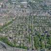
Aerial view including Grange cemetery, Grange Road, Lauder Road, Dick Place, Sciennes seen from the South South West. |
1993 |
Item Level |
|
 |
On-line Digital Images |
SC 1677892 |
RCAHMS Aerial Photography |
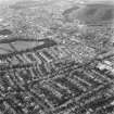
Aerial view including Salisbury Crags, Lauder Road, the Meadows, Sciennes, Dick Place, Grange Road, Causewayside, George Square seen from the South. |
1993 |
Item Level |
|
 |
On-line Digital Images |
DP 304033 |
Historic Environment Scotland |
Oblique aerial view. |
15/5/2019 |
Item Level |
|


