 |
On-line Digital Images |
SC 881290 |
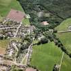
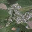
RCAHMS Aerial Photography |
Strathpeffer, oblique aerial view, taken from the NW, showing the southwest part of Strathpeffer town. |
23/6/1995 |
Item Level |
|
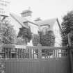 |
On-line Digital Images |
SC 1643475 |
List C Survey |
General view |
1975 |
Item Level |
|
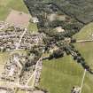 |
On-line Digital Images |
SC 1676414 |
RCAHMS Aerial Photography |
Strathpeffer, oblique aerial view, taken from the NW, showing the southwest part of Strathpeffer town. |
23/6/1995 |
Item Level |
|
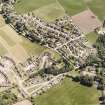 |
On-line Digital Images |
SC 1676415 |
RCAHMS Aerial Photography |
Strathpeffer, oblique aerial view, taken from the SW, showing the southwest part of Strathpeffer town. |
23/6/1995 |
Item Level |
|
 |
On-line Digital Images |
SC 2361917 |
Records of the Ordnance Survey, Southampton, Hampshire, England |
Strathpeffer, Lynnmhor, NH45NE 38, Ordnance Survey index card, Recto |
c. 1958 |
Item Level |
|
 |
On-line Digital Images |
SC 2703004 |
RCAHMS Aerial Photography |
Strathpeffer, oblique aerial view, taken from the SE, showing the southwest part of Strathpeffer town. |
23/6/1995 |
Item Level |
|


