 |
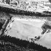
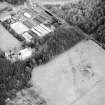
On-line Digital Images |
SC 1729312 |
RCAHMS Aerial Photography |
Kinneil Roman Fortlet, oblique aerial view, taken from the SSE. |
20/2/1996 |
Item Level |
|
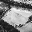 |
On-line Digital Images |
SC 1729313 |
RCAHMS Aerial Photography |
Kinneil Roman Fortlet, oblique aerial view, taken from the ESE. |
20/2/1996 |
Item Level |
|
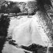 |
On-line Digital Images |
SC 1729314 |
RCAHMS Aerial Photography |
Kinneil Roman Fortlet, oblique aerial view, taken from the ENE. |
20/2/1996 |
Item Level |
|
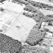 |
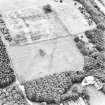
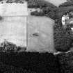
On-line Digital Images |
SC 1729320 |
|
Oblique aerial view, taken from the SE, centred on a linear cropmark cutting across the route of the Antonine Wall. |
27/7/1996 |
Item Level |
|
 |
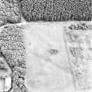
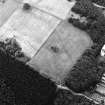
On-line Digital Images |
SC 1729321 |
|
Oblique aerial view, taken from the E, centred on a linear cropmark cutting across the route of the Antonine Wall. |
29/7/1996 |
Item Level |
|
 |
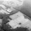
On-line Digital Images |
SC 1729322 |
RCAHMS Aerial Photography |
Kinneil House, oblique aerial view, taken from the NE, centred on a linear cropmark cutting across the route of the Antonine Wall. |
29/7/1996 |
Item Level |
|
 |
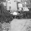
On-line Digital Images |
SC 1729326 |
RCAHMS Aerial Photography |
Oblique aerial view of Bo'ness, Kinneil, centred on the cropmarks of the Antonine Wall with a church and tower-house adjacent, taken from the NW. |
20/8/1997 |
Item Level |
|
 |
On-line Digital Images |
SC 1729327 |
RCAHMS Aerial Photography |
Oblique aerial view of Bo'ness, Kinneil, centred on the cropmarks of the Antonine Wall with a church and tower-house adjacent, taken from the SW. |
20/8/1997 |
Item Level |
|
 |
On-line Digital Images |
SC 1729328 |
RCAHMS Aerial Photography |
Oblique aerial view of Bo'ness, Kinneil, centred on the cropmarks of the Antonine Wall with a church and tower-house adjacent, taken from the SSE. |
20/8/1997 |
Item Level |
|
 |
On-line Digital Images |
SC 1729329 |
RCAHMS Aerial Photography |
Oblique aerial view of Bo'ness, Kinneil, centred on the cropmarks of the Antonine Wall with a church adjacent, taken from the SE. |
20/8/1997 |
Item Level |
|
 |
On-line Digital Images |
SC 1729330 |
RCAHMS Aerial Photography |
Aerial view of Kinneil House, Old Kinneil Kirk and the Antonine Wall (c. 9800 8052), taken from the NNE. |
5/2/1997 |
Item Level |
|
 |
On-line Digital Images |
SC 1729331 |
RCAHMS Aerial Photography |
Aerial view of Kinneil House, Old Kinneil Kirk and the Antonine Wall (c. 9800 8052), taken from the NE. |
5/2/1997 |
Item Level |
|
 |
On-line Digital Images |
SC 1729332 |
RCAHMS Aerial Photography |
Aerial view of the Antonine Wall (c. 9800 8052), Kinneil House and Old Kinneil Kirk, taken from the NW. |
5/2/1997 |
Item Level |
|
 |
On-line Digital Images |
SC 1729333 |
RCAHMS Aerial Photography |
Aerial view of Kinneil House, Old Kinneil Kirk and the Antonine Wall, taken from the W. |
5/2/1997 |
Item Level |
|
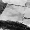 |
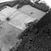
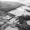
On-line Digital Images |
SC 1729338 |
RCAHMS Aerial Photography |
Aerial view of the Antonine Wall (c. 9727 8007 - 9754 8016) and the military way, taken from the N. |
4/3/1997 |
Item Level |
|
 |
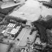
On-line Digital Images |
SC 1729339 |
RCAHMS Aerial Photography |
Aerial view of the Antonine Wall (c. 9727 8007 - 9754 8016) and the military way, taken from the NW. |
4/3/1997 |
Item Level |
|
 |
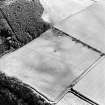
On-line Digital Images |
SC 1729340 |
RCAHMS Aerial Photography |
Aerial view of the Antonine Wall (c. 9727 8007 - 9754 8016) and the military way, taken from the WSW. |
4/3/1997 |
Item Level |
|
 |
On-line Digital Images |
SC 1729341 |
RCAHMS Aerial Photography |
Aerial view of the Antonine Wall (c. 9727 8007 - 9754 8016) and the military way, taken from the SW. |
4/3/1997 |
Item Level |
|
|
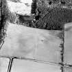
Photographs and Off-line Digital Images |
SC 1918608 |
Cambridge University Collection for Aerial Photography |
Oblique aerial view |
11/7/1951 |
Item Level |
|
|
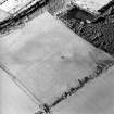
Photographs and Off-line Digital Images |
SC 1918609 |
Cambridge University Collection for Aerial Photography |
Oblique aerial view |
27/7/1963 |
Item Level |
|
|
Photographs and Off-line Digital Images |
SC 1931156 |
Cambridge University Collection for Aerial Photography |
Oblique aerial view |
31/7/1975 |
Item Level |
|
 |
On-line Digital Images |
SC 1970706 |
Records of Historic Scotland, Edinburgh, Scotland |
Antonine Wall 1:25000 broadsheet map |
2008 |
Item Level |
|
|
Digital Files (Non-image) |
GV 008531 |
Records of Historic Scotland, Edinburgh, Scotland |
Map showing the Antonine Wall, the World Heritage Site area, the areas of the World Heritage Site in public ownership or care, the Buffer Zone and the Council boundaries. Created for the World Heritage Site nomination - Management plan. |
2006 |
Item Level |
|
 |
On-line Digital Images |
SC 2170806 |
Records of Historic Scotland, Edinburgh, Scotland |
Map showing the Antonine Wall, the World Heritage Site area, the areas of the World Heritage Site in public ownership or care, the Buffer Zone and the Council boundaries. Created for the World Heritage Site nomination - Management plan. |
2006 |
Item Level |
|


