 |
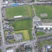
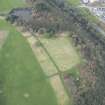
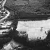
On-line Digital Images |
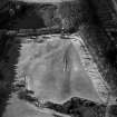
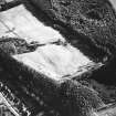
SC 624027 |
RCAHMS Aerial Photography |
Kinneil Roman Fortlet, oblique aerial view, taken from the ENE. |
20/2/1996 |
Item Level |
|
 |
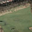
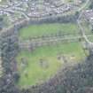
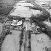
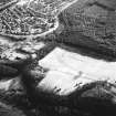
On-line Digital Images |
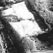
SC 624727 |
RCAHMS Aerial Photography |
Kinneil House, oblique aerial view, taken from the NE, centred on a linear cropmark cutting across the route of the Antonine Wall. |
29/7/1996 |
Item Level |
|
 |
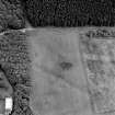
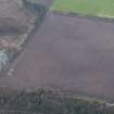
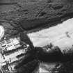
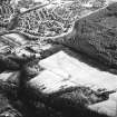
On-line Digital Images |
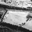
SC 902614 |
RCAHMS Aerial Photography |
Oblique aerial view of Kinneil fortlet and the Antonine Wall (c. 9800 8052), taken from the SSE. |
4/3/1997 |
Item Level |
|
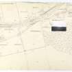 |
On-line Digital Images |
DP 051469 |
Records of the Royal Commission on the Ancient and Historical Monuments of Scotland (RCAHMS), Edinbu |
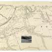
Antonine Wall Ordnance Survey 1954-57 working sheets map sheet 43 |
c. 1957 |
Item Level |
|
 |
On-line Digital Images |
DP 051470 |
Records of the Royal Commission on the Ancient and Historical Monuments of Scotland (RCAHMS), Edinbu |
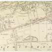
Antonine Wall Ordnance Survey 1954-57 working sheets map sheet 44 |
c. 1957 |
Item Level |
|
 |
On-line Digital Images |
DP 051471 |
Records of the Royal Commission on the Ancient and Historical Monuments of Scotland (RCAHMS), Edinbu |
Antonine Wall Ordnance Survey 1954-57 working sheets map sheet 45 |
c. 1957 |
Item Level |
|
 |
On-line Digital Images |
DP 051525 |
Records of the Royal Commission on the Ancient and Historical Monuments of Scotland (RCAHMS), Edinbu |
Antonine Wall Ordnance Survey 1954-57 working sheets map sheet 43 |
c. 1957 |
Item Level |
|
 |
On-line Digital Images |
DP 051526 |
Records of the Royal Commission on the Ancient and Historical Monuments of Scotland (RCAHMS), Edinbu |
Antonine Wall Ordnance Survey 1954-57 working sheets map sheet 44 |
c. 1957 |
Item Level |
|
 |
On-line Digital Images |
DP 249485 |
Historic Environment Scotland |
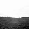
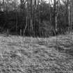
Oblique aerial view. |
24/3/2017 |
Item Level |
|
 |
On-line Digital Images |
DP 249486 |
Historic Environment Scotland |
Oblique aerial view. |
24/3/2017 |
Item Level |
|
 |
On-line Digital Images |
DP 249487 |
Historic Environment Scotland |
Oblique aerial view. |
24/3/2017 |
Item Level |
|
 |
On-line Digital Images |
DP 249488 |
Historic Environment Scotland |
Oblique aerial view. |
24/3/2017 |
Item Level |
|
 |
On-line Digital Images |
DP 249489 |
Historic Environment Scotland |
Oblique aerial view. |
24/3/2017 |
Item Level |
|
 |
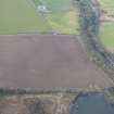
On-line Digital Images |
SC 1669504 |
RCAHMS Aerial Photography |
Aerial view of Kinneil House, Old Kinneil Kirk and the Antonine Wall (c. 9800 8052), taken from the NE. |
5/2/1997 |
Item Level |
|
 |
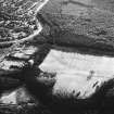
On-line Digital Images |
SC 1729304 |
|
Kinneil, oblique aerial view, taken from the N, centred on the section of the Antonine Wall running adjacent to Old Kinneil Kirk. |
20/2/1996 |
Item Level |
|
 |
On-line Digital Images |
SC 1729305 |
|
Kinneil, oblique aerial view, taken from the NNW, centred on the section of the Antonine Wall running adjacent to Old Kinneil Kirk. |
20/2/1996 |
Item Level |
|
 |
On-line Digital Images |
SC 1729306 |
|
Kinneil, oblique aerial view, taken from the NNW, centred on the section of the Antonine Wall running adjacent to Old Kinneil Kirk. |
20/2/1996 |
Item Level |
|
 |
On-line Digital Images |
SC 1729307 |
|
Kinneil, oblique aerial view, taken from the NW, centred on the section of the Antonine Wall running adjacent to Old Kinneil Kirk. |
20/2/1996 |
Item Level |
|
 |
On-line Digital Images |
SC 1729308 |
|
Kinneil, oblique aerial view, taken from the NW, centred on the section of the Antonine Wall running adjacent to Old Kinneil Kirk. |
20/2/1996 |
Item Level |
|
 |
On-line Digital Images |
SC 1729309 |
|
Kinneil, oblique aerial view, taken from the WNW, centred on the section of the Antonine Wall running adjacent to Old Kinneil Kirk. |
20/2/1996 |
Item Level |
|
 |
On-line Digital Images |
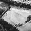
SC 1729310 |
|
Kinneil Roman Fortlet, oblique aerial view, taken from the WNW. |
20/2/1996 |
Item Level |
|
 |
On-line Digital Images |
SC 1729311 |
|
Kinneil Roman Fortlet, oblique aerial view, taken from the W. |
20/2/1996 |
Item Level |
|
 |
On-line Digital Images |
SC 1729312 |
RCAHMS Aerial Photography |
Kinneil Roman Fortlet, oblique aerial view, taken from the SSE. |
20/2/1996 |
Item Level |
|
 |
On-line Digital Images |
SC 1729313 |
RCAHMS Aerial Photography |
Kinneil Roman Fortlet, oblique aerial view, taken from the ESE. |
20/2/1996 |
Item Level |
|


