 |
On-line Digital Images |
DP 109263 |
RCAHMS Aerial Photography Digital |
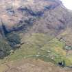
Oblique aerial view of the remains of the township, field system and cultivation remains at Kilbride, also showing the location of High Pasture Cave, Strath Suardal, Skye, taken from the NNE. |
30/4/2011 |
Item Level |
|
 |
On-line Digital Images |
DP 109264 |
RCAHMS Aerial Photography Digital |
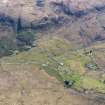
Oblique aerial view of the remains of the township of Kilbride and the nearby field system and cultivation remains, also showing the location of High Pasture Cave, Strath Suardal, Skye, taken from the N. |
30/4/2011 |
Item Level |
|
 |
On-line Digital Images |
DP 109267 |
RCAHMS Aerial Photography Digital |
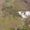
Oblique aerial view of the Cnoc Dubh marble quarry at Torrin, also showing the nearby remains of field systems, head dykes and lazy beds at Torrin and Kilbride, Skye, taken from the NW. |
30/4/2011 |
Item Level |
|
 |
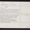
On-line Digital Images |
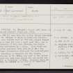
SC 2359774 |
Records of the Ordnance Survey, Southampton, Hampshire, England |
Skye, Kilbride, St Bridget's Chapel, NG52SE 3, Ordnance Survey index card, Recto |
c. 1958 |
Item Level |
|
 |
On-line Digital Images |
SC 2359775 |
Records of the Ordnance Survey, Southampton, Hampshire, England |
Skye, Kilbride, St Bridget's Chapel, NG52SE 3, Ordnance Survey index card, page number 1, Recto |
c. 1958 |
Item Level |
|
 |
On-line Digital Images |
SC 2359776 |
Records of the Ordnance Survey, Southampton, Hampshire, England |
Skye, Kilbride, St Bridget's Chapel, NG52SE 3, Ordnance Survey index card, page number 2, Verso |
c. 1958 |
Item Level |
|


