 |
On-line Digital Images |
SC 1233234 |
Scotland's Rural Past |
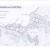
Port Henderson: township plan showing croft boundaries |
2011 |
Item Level |
|
 |
On-line Digital Images |
DP 098013 |
Scotland's Rural Past |
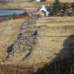
Port Henderson: ruined fishing village on Coft 22 |
2010 |
Item Level |
|
 |
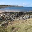
On-line Digital Images |
DP 098014 |
Scotland's Rural Past |
Port Henderson: ruined slipway/port and ruined fishing village on Croft 21 |
2010 |
Item Level |
|
 |
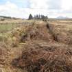
On-line Digital Images |
DP 098015 |
Scotland's Rural Past |
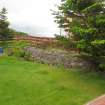
Port Henderson: remaining wall of boat builders shed on Croft 22 |
2010 |
Item Level |
|
 |
On-line Digital Images |
DP 098016 |
Scotland's Rural Past |
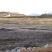
Port Henderson: ruined slipway/port on Croft 13 |
2010 |
Item Level |
|
 |
On-line Digital Images |
DP 098017 |
Scotland's Rural Past |
Port Henderson: old access passage between Crofts 14 and 12 |
2010 |
Item Level |
|
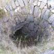 |
On-line Digital Images |
DP 098018 |
Scotland's Rural Past |
Port Henderson: bowl of corn drying kiln on An Sguman |
2009 |
Item Level |
|
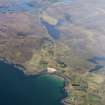 |
On-line Digital Images |
DP 110047 |
RCAHMS Aerial Photography Digital |
General oblique aerial view looking across Port Henderson towards Badchro, taken from the W. |
1/5/2011 |
Item Level |
|


