 |
On-line Digital Images |
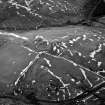
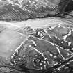
SC 624021 |
RCAHMS Aerial Photography |
Camp Hill, Bailiehill, oblique aerial view, taken from the ESE, centred on a fort and settlement and on an enclosure and cultivation remains. Bailiehill farmstead is visible in the bottom centre of the photograph. |
14/2/1996 |
Item Level |
|
 |
On-line Digital Images |
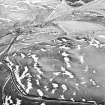
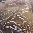
SC 1761137 |
RCAHMS Aerial Photography |
Camp Hill, Bailiehill, oblique aerial view, taken from the NW, centred on a fort and settlement and on an enclosure and cultivation remains. Bailiehill farmstead and an 'enclosure' and cultivation remains are visible in the top half of the photograph. |
14/2/1996 |
Item Level |
|
 |
On-line Digital Images |
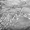
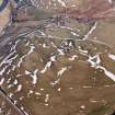
SC 1761138 |
RCAHMS Aerial Photography |
Camp Hill, Bailiehill, oblique aerial view, taken from the NW, centred on a fort and settlement and on an enclosure and cultivation remains. Bailiehill farmstead is visible in the centre top half of the photograph. |
14/2/1996 |
Item Level |
|
 |
On-line Digital Images |
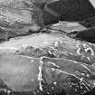
SC 1761139 |
RCAHMS Aerial Photography |
Camp Hill, Bailiehill, oblique aerial view, taken from the SE, centred on a fort and settlement and on an enclosure and cultivation remains. Bailiehill farmstead is visible in the bottom right-hand corner of the photograph. |
14/2/1996 |
Item Level |
|
 |
On-line Digital Images |
SC 1761140 |
RCAHMS Aerial Photography |
Camp Hill, Bailiehill, oblique aerial view, taken from the ESE, centred on a fort and settlement and on an enclosure and cultivation remains. Bailiehill farmstead is visible in the bottom centre of the photograph. |
14/2/1996 |
Item Level |
|
 |
On-line Digital Images |
SC 1761161 |
|
Camp Hill, Bailiehill, oblique aerial view, taken from the NNE, centred on a fort and settlement and on an enclosure and cultivation remains. Bailiehill farmstead and an 'enclosure' and cultivation remains are visible in the top left-hand corner of the photograph. |
14/2/1996 |
Item Level |
|
 |
On-line Digital Images |
SC 1761162 |
|
Camp Hill, Bailiehill, oblique aerial view, taken from the NW, centred on a fort and settlement and on an enclosure and cultivation remains. Bailiehill farmstead is visible in the centre top half of the photograph. |
14/2/1996 |
Item Level |
|


