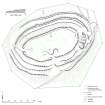
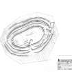
Measured Survey


Date 16 November 2005
Event ID 1136946
Category Recording
Type Measured Survey
Permalink http://canmore.org.uk/event/1136946
RCAHMS surveyed Castlelaw fort, Glencorse with plane-table and self-reducing alidade on 16 November 2005 at a scale of 1:500. Control points were established by differential GPS. The resultant plan was redrawn in vector graphics software at a scale of 1:1000.