Pricing Change
New pricing for orders of material from this site will come into place shortly. Charges for supply of digital images, digitisation on demand, prints and licensing will be altered.
Upcoming Maintenance
Please be advised that this website will undergo scheduled maintenance on the following dates:
Thursday, 9 January: 11:00 AM - 3:00 PM
Thursday, 23 January: 11:00 AM - 3:00 PM
Thursday, 30 January: 11:00 AM - 3:00 PM
During these times, some functionality such as image purchasing may be temporarily unavailable. We apologise for any inconvenience this may cause.
Field Visit
Date 12 April 1921
Event ID 1114391
Category Recording
Type Field Visit
Permalink http://canmore.org.uk/event/1114391
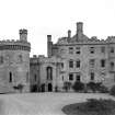
Dalhousie Castle.
This castle stands on the left bank of the South Esk, about a mile and a quarter south-east of Bonnyrigg and 2 miles north-west of Gorebridge, in the angle formed by the river and its tributary theDalhousie Burn. Its position has possibly been determined by the proximity of a suitable quarry, for, while it is naturally of some little strength, it is relatively low lying, rising with a gentle slope from the river, which winds northwards past the site. The enclosure is rough square and is set with its southern side on the brink of the steepest part of the bank. The other sides were protected by a ditch, now filled in but shown in 18th-century views of the castle. As the castle is set back on the east about 100 yards from the river, there remained beyond the house an area enclosed by ditch and river, which is shown in a water-colour drawing of I749 in the Laing Collection of the Royal Scottish Academy as bounded by a wall and occupied by a long barn-like structure and a 16th-century circular dovecot with a later roof. This area is now a lawn and of these latter structures no vestige remains.
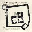
Dalhousie Castle (Fig. 36) was originally a 15th-century tower standing within a court enclosed by high curtains, and in type and period was similar to its neighbour at Borthwick, which is only 4 miles distant. Unlike Borthwick, however, it has been greatly altered and extended from the late 16th or early 17thcentury onwards to the present day.
The 15th-century tower is L-shaped on plan with its main block, 62 feet long by 37 ½ feet wide, lying east and west; the wing projects 20 feet northward in continuation of the east gable and originally had a width of 29 feet, which was increased in the early 17th century to 44 feet to contain a main staircase, later replaced by the present modern stair. Below the staircase, that is, on the basement and entresol floors, the north wall is in continuation of the north wall of the wing and is 11 feet thick, while above these floors it is set back6 inches, and its masonry indicates its date in moulded window jambs to north and west and string-courses. The addition, indicated on the plan by stipple, has on the west face three circular panels within garland borders, the outer panels being armorial. The northern has a shield bearing the eagle displayed of Ramsay of Dalhousie, the southern a shield charged with two mullets in chief and three piles charged with a mullet, for Douglas of Lochleven and Dalkeith. The central panel is initialled S. G. R. for Sir George Ramsay (knighted before 1603), and D. M. D. for Dame Margaret Douglas, his first wife, a niece of the sixth Earl of Morton.
[See RCAHMS 1929 pp.12-15 for a full architectural description].
RCAHMS 1929, visited 12 April 1921.


