
The remains of the township of Five Pennies, lying to the north of Howlin farmhouse, are clustered at the edge of an extensive and irregular field system.
The township consists of the visible remains of about two dozen buildings, including a corn-drying kiln, several small yards, and agricultural enclosures.
The name "Five Pennies" may come from a medieval assessment of the lands of Howlin in 1498, when James IV granted 5 pennies of land there to Ranald Macallan of Clanranald.
The concept of "pennylands" was a method of assigning value to a piece of farmland according to its fertility. 'Pennylands' were subdivisions of the pre-existing 'ounce-lands', a method of division that may have Norse origins.
Around Five Pennies there are well-preserved field systems with turf and stone dykes, which - apart from informing us about cultivation practices and areas - can also give us an indication of social changes within the landscape.
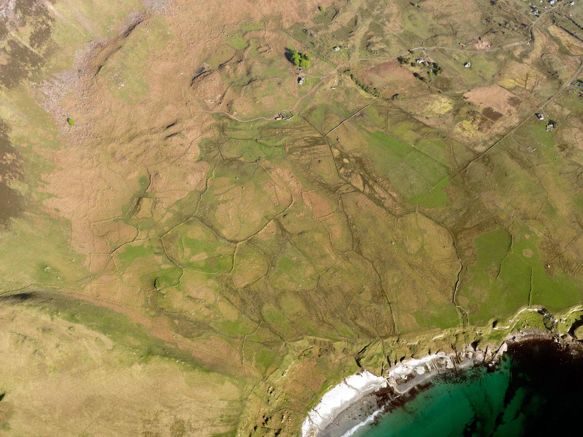
We can clearly see two phases of land use. The irregular system that runs higgledy-piggledy around the north of the township represents a pre-crofting landscape. Here, land appears to have been demarcated as and when fields were required, and the divisions correlate with the natural topography.

However, to the south of the township we can see that the land has been organised into straight, uniform, and narrow strips running from the cliffs to the bay. This kind of system is typical of a crofting township; the uniformity and disregard of natural topography suggests that the crofts have been planned on paper first, which indicates that this land was owned by an estate and divided up for tenant farmers.

This change in the landscape fits with what we know of the history of Five Pennies: once the township was cleared in the 18th century, (with Howlin house being built soon after in 1770,) the estate was divvied up into uniform crofts to accommodate several tenant farmers.
The uniformity of the ruined buildings at Five Pennies presents a challenge for archaeologists, as it makes it difficult to say for certain what the function of many of them was. What, for instance, can differentiate a cotter's house from simply a small stone storehouse when most of the material has been robbed or eroded? Hence, we can only suggest the function of particular buildings, using their features as a guide.

Most of the buildings are roughly rectangular, with rounded external corners and a turf core faced on both sides with large stones. Visiting the area in 1700, Bishop William Nicolson noted the differences between houses here and on the mainland, and attributed the use of turf cores to wind resistance and insulation.

The builders utilised local stone, often robbed from pre-existing structures– indeed, this seems to have been the preferred method of acquiring stone on the island.
This building style is found elsewhere on Eigg in other pre-crofting communities such as Braighe, and contrasts with the rubble-cored walls that characterise later settlements such as Grulin. It appears typical of the island's 17th and 18th centuries (although the settlement itself is likely to be even older).
Amongst the buildings, we can determine the remains of agricultural structures, and we will now look at some of the features we can use to help us identify these.
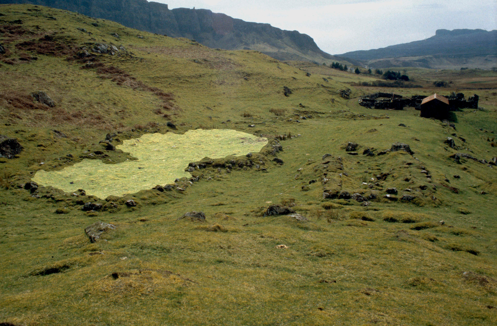
The structure highlighted is probably an agricultural enclosure – possibly used only on a temporary basis - and we can suggest this for a number of reasons.

Firstly, we can see that it has been extended and made larger, possibly to accommodate more animals.


Secondly, the interior earth is devoid of any raised or depressed earth. This suggests that the ground within it was not used very often. It is possible hence that this enclosure was used as a holding pen for animals, perhaps when specific seasonal tasks associated with them needed to be carried out.
Truly domestic buildings are largely unfathomable amongst the ruins at Five Pennies, as the diagnostic features needed to identify them are missing. There are certainly some small cotter's houses - that would have been occupied by the poorest members of the community - at the edge of the township, but many of the buildings have lost their structural integrity to such an extent that they are indistinguishable.
However, it is possible that the building on the right is both agricultural and domestic; we can theorise from its features that it may be a byre-house.
Firstly, its size and shape is similar to other examples of known byre-houses from the same period.
But secondly, it is south-facing (away from the rest of the township) and built on a slope. Byre-houses were often built on slopes, so that any waste produced by the cattle (often just one cow, but sometimes more) could flow directly down the slope and out of the building, away from the domestic quarters.

How these buildings may have looked in their heyday cannot be deduced from the remains at Five Pennies alone, but given the description from Bishop Nicolson and the evidence of turf-core walls, we can suggest that all probably shared the similar construction technique of low stone walls with a turf and thatch roof supported by timber frames. Relatively little timber was needed to hold up a heavy turf and thatch roof, making it a simple, but effective technique.
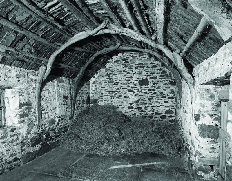
This technique often leaves nothing but low, relatively wide stone foundations once the building is abandoned and this is exactly what we see at Five Pennies.
