
Johnscleugh


Enclosure (Post Medieval), Shieling Hut(S) (Medieval) - (18th Century)
Site Name Johnscleugh
Classification Enclosure (Post Medieval), Shieling Hut(S) (Medieval) - (18th Century)
Alternative Name(s) Back Burn, Writerspath Burn
Canmore ID 57503
Site Number NT66NW 4
NGR NT 63696 66147
NGR Description Centre
Datum OSGB36 - NGR
Permalink http://canmore.org.uk/site/57503


- Council East Lothian
- Parish Whittingehame
- Former Region Lothian
- Former District East Lothian
- Former County East Lothian
NT66NW 4 636 664
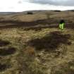
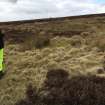
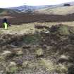
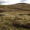
(NT 636 664) There is a group of small, excavated hollows (at 1000ft OD) some 500 yards E of Johnscleugh, between Back Burn and Writerspath Burn. They lie on a slope, in a line running NNE-SSW.
The first (A) is oval, measuring 12ft by 8ft and 1 1/2ft deep. 'B', 20 yards SSW of 'A', is circular, 9ft in diameter and is surrounded by a slight wall 3-4ins high. 'C' , 38 yards SSW of 'B', is similar to 'A', but less distinct. 'D', 40ft from 'C', is 18ft by 10ft with a wall 3ft broad and 4-6ins high on its flanks; some 20 yards SW there is evidence of two adjoining hollows, too indistinct for measurement. 'E', 115 yards SSW of 'D' on top of the brae running down to the Whiteadder, is a rectangular area with rounded corners, measuring 17ft by 8 1/2ft with a wall 4 1/2ft broad; it seems to have been divided into two compartments. Adjacent to its W end is an oval hollow, 13ft by 8ft and there are faint traces of another group 15ft W.
An earthen wall, 5ft broad and 1ft high and 200 yards long, runs from the top of the brae to form an enclosure, giving access to the river. Probably this enclosure and the excavations are contemporary and tend to confirm the idea that these hollows are the remains of shielings.
RCAHMS 1924, visited 1913.
None of these features was identified in the indicated area. There are numerous natural hollows and depressions in the vicinity of a dry gully at NT 635 663.
Visited by OS (JRL), 4 May 1979.
Field Visit (13 June 1913)
223. Small Excavated Hollows, Ling Rig, Johnscleugh.
Some 500 yards east of Johnscleugh, at an elevation of 1000 feet above sea-level, on the sloping summit of the Ling Rig, which lies between the Back Burn and the Writerspath Burn, is a group of small excavated hollows, placed almost in a line, running north-north-east and south-south-west, the major axes of the hollows being across this line. The first is oval in shape, 12 feet long, 8 feet broad and 1 foot 6 inches deep; the second 20 yards to the south-south-west is circular and 9 feet in diameter, while it is surrounded by a slight wall 3 or 4 inches in height; the third, 38 yards farther on in the same direction, is of the same length and breadth as the first but is less distinct; the fourth, 40 feet distant, showing a wall3 feet broad and 4 to 6 inches high on the flanks, is 18 feet long by 10 feet broad; some 20 yards to south-west there is evidence of two adjoining hollows, too indistinct for measurement; 115 yards south-south-west of the fourth, on the top of the brae running down to the left bank of the Whitadder, there is a rectangular area with rounded corners,17 feet long by 8 feet 6 inches broad, which seems to have been divided into two compartments, the wall being 4 feet 6 inches broad and showing an entrance on the southern side, while adjacent to the western end, there is an oval hollow 13 feet long. by 8 feet broad; and 15 feet to the west there are faint traces of another group. Along the top of the brae, about 150 feet above the Whitadder, for a distance of about 200 yards, an earthen wall, 5 feet in breadth and I foot in height, has been thrown up, the ends being carried straight down the steep slope of the hill to the grassy haugh on the left bank of the river, forming an enclosure which would give access to water. Probably the excavations and the enclosure are contemporary and tend to confirm the idea that these hollows are the remains of shielings.
RCAHMS 1924, visited 13 June 1913.
OS Map ref: xvi. N.E. (unnoted).
Field Visit (6 March 2020)
The location, classification and period of this site have been reviewed.

