
Stow, Station Road, Stow Station


Footbridge (19th Century), Railway Station (19th Century), Railway Yard (19th Century)
Site Name Stow, Station Road, Stow Station
Classification Footbridge (19th Century), Railway Station (19th Century), Railway Yard (19th Century)
Alternative Name(s) The Waverley Line; Stow For Lauder Station; Edinburgh To Hawick Branch Railway
Canmore ID 100381
Site Number NT44SE 28.01
NGR NT 45612 44629
Datum OSGB36 - NGR
Permalink http://canmore.org.uk/site/100381


- Council Scottish Borders, The
- Parish Stow
- Former Region Borders
- Former District Ettrick And Lauderdale
- Former County Midlothian
NT44SE 28.01 45612 44629
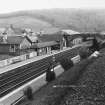
This intermediate station on the Edinburgh-Carlisle 'Waverley route' of the former North British Rly was opened by that company on 1 November 1848; it was noted as 'Stow for Lauder' in some timetables. The station closed to regular passenger traffic (with the line as whole) on 6 January 1969.
Information from RCAHMS (RJCM), 7 June 2000.
R V J Butt 1995.
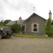
The Object Name Book of the Ordnance Survey describes 'Stow Railway Station' as ' A small dwelling house and offices houses are in good repair they are the property of the North British Railway Company and built by them for a dwelling house, booking office etc for the station master' (Name Book 1852).
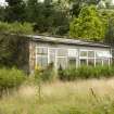
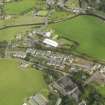
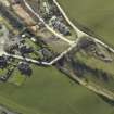
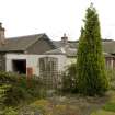
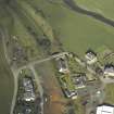
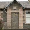
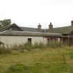
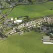
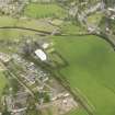
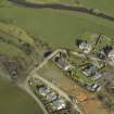
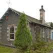
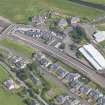
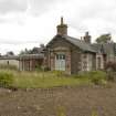
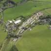
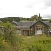
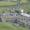
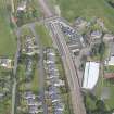
The station house and booking office is situated on the E side of the trackbed about 55m N of a new school which has been built on the goods yard. Built of sandstone it has been converted to a dwelling house.
The station house was located on the up (Hawick/Carlisle) platform with the down (Edinburgh platform), only supplied with a small shelter. Both platforms have now been demolished or are covered by garden infill and the area forms part of a garden for a new house built across the trackbed immediately S of the road overbridge.
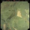
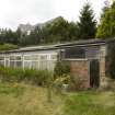
The railway goods yard and goods shed (NT44SE 28.03) was situated immediately S of the station building. The site of the yard has now been built over.
The station orignally opened as part of the Edinburgh to Hawick Branch railway.
Visited by RCAHMS (DE), July 2006
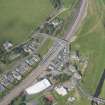
The area between the platforms also forms a garden for the station house. Immediately S of the small car park on the S side of the station building was the site of the goods shed and a footbridge which crossed the line at this point has also been removed.
Visited by RCAHMS (DE, JM), 19 August 2009
Field Visit (April 2009 - February 2015)
The Borders Railway Project proposals are to reinstate the Newcraighall to Tweedbank section of the former Waverley Line. The reinstated railway line will be approximately 48km long and the majority of the route will use the existing railway embankment.
Several field surveys, archaeological evaluations and standing building surveys were undertaken by CFA Archaeology from April 2009 until February 2015.
CFA Archaeology
Standing Building Recording (October 2011 - February 2012)
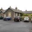
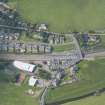
NT 4564 4454 Stow Station was built in the Victorian revivalist style and occupies roughly a Z-shaped plan with an assortment of 20th-century additions attached to its E and W-facing external elevations. The building is constructed of snecked sandstone and has ashlar dressings. The S-facing elevation incorporates a pedimented arch with pilasters. Historical photographs show that the arch housed the station clock. The interior of the building has been refurbished to suit the needs of 20th-century living, and there are no surviving period features associated with its former use as a ticket office and station masters house.
NT 4772 3858 The Torwoodlee gate piers are located on a minor trackway leading from the N to the Torwoodlee mansion house. The piers were hewn from single blocks of sandstone and are probably of mid-19th-century date.
NT 51572 35251 A Level 1 survey was carried out on the Category B Galafoot (Redbridge) Railway Viaduct located to the E of Galashiels. The viaduct was constructed in c1849 to cross the River Tweed for the North British Railway and formed the first part of the Waverley Railway Line from Edinburgh to Carlisle. Also known as the Tweed or Redbridge Viaduct, it is constructed of squared sandstone rubble with ashlar voussoirs on its segmental arches. The piers consist of rusticated sandstone with boat-shaped cutwaters on the upstream and downstream sides. The parapet is constructed of sandstone with ashlar copings. The viaduct is approached along embankments on both sides of the river. The 1972 OS map shows a massive stone abutment to the W of the stream, while the viaduct also crosses a track to the E of the river. The Waverley Railway, which closed to regular passenger traffic on 6 January 1969 and much of the route in Midlothian, currently forms part of a cycle track.
Archive: RCAHMS (intended). Report: Scottish Borders HER and RCAHMS
Funder: ERM Ltd on behalf of Transport Scotland
Stuart Mitchell, Graeme Carruthers, Mike Cressey - CFA Archaeology Ltd, 2013
(Source: DES)
Standing Building Recording (9 October 2012 - 5 November 2012)
Three individual archaeological standing building recording surveys were carried out by CFA Archaeology Ltd (CFA) between October and November 2011. The work was undertaken in advance of the construction of the
Borders Railway Project. The work was requested by the Scottish Borders Council Archaeologist and is detailed in the Cultural Heritage Management Plan (Jones & Neighbour 2010) for the development. Site numbers relate to study specific numbers from the Environmental Statement.
The three sites that were subjected to a standing building survey were:
Langhaugh Mill Complex, Galashiels, (Site 417) (NGR NT 49763583)
Station House, Stow, (Site 204) (NGR NT 45644454)
Torwoodlee Gate Piers, (Site 509) (NGR NT47723858)
Information from Oasis (cfaarcha1-119211) 20 August 2012

