
Edinburgh, Holyrood Park, Clockmill House, Walled Garden And Botanic Garden


House (Period Unassigned)
Site Name Edinburgh, Holyrood Park, Clockmill House, Walled Garden And Botanic Garden
Classification House (Period Unassigned)
Alternative Name(s) Queen's Park; Belle Ville; Belville
Canmore ID 157265
Site Number NT27SE 3955
NGR NT 2723 7402
Datum OSGB36 - NGR
Permalink http://canmore.org.uk/site/157265


- Council Edinburgh, City Of
- Parish Edinburgh (Edinburgh, City Of)
- Former Region Lothian
- Former District City Of Edinburgh
- Former County Midlothian
NT27SE 3955 2723 7402
See also NT27SE 197.
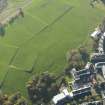
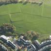
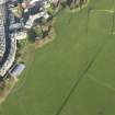
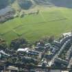
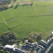
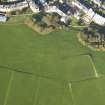
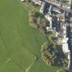
There are no visible remains of Clockmill House and its walled garden, which formerly stood in the centre of the area to the E of Holyrood Palace now used as playing fields. It is shown as Clockmill House and Botanic Garden on Alexander Kirkwood's map of 1817, but, on a map of Holyrood Abbey Sanctuary and Environs, dated 1839, the garden is annotated as an 'old botanic garden', and the house, although retaining its title, is shown with the name of 'Belle Ville' written in italics on its W side. Belleville was the name of the estate, and on the OS 1:1056 maps of 1853 and 1881, the house is known only as Belville (Edinburgh and its environs 1853 and 1881, sheet 31). The estate was purchased by the crown in 1877 as an extension to the Park, and no trace of the house and garden appear on the OS 25-inch map of 1896 (Edinburghshire 1896, sheet iii.8). A late-eighteenth century illustration of Clockmill House shows it as a three-storeyed house surrounded by woodland (Grant 1882, 308), but this appears to have been replaced by the house depicted on the later maps.
Vertical aerial photography (BKS 2274 040, flown 28 June 1973) has recorded three sides of a rectilinear parchmark, and this roughly coincides with the position of the foundations of the house.
Visited by RCAHMS (ARG), 15 December 1998.
NMRS, MS/726/96 (75-6, no. 86); J Grant {1882}.
Condition Survey (12 March 2018 - 15 April 2018)
The 2018 survey found the site as previously described with nothing visible on the ground.
Information from Graeme Carruthers (CFA Archaeology Ltd) July 2018. OASIS ID: cfaarcha1-317194, no.86

