
Bute, Loch Dhu Dam


Dam (19th Century), Sluice (19th Century)
Site Name Bute, Loch Dhu Dam
Classification Dam (19th Century), Sluice (19th Century)
Alternative Name(s) Robert Thom's Water Cuts
Canmore ID 304558
Site Number NS06SE 427
NGR NS 06285 61505
Datum OSGB36 - NGR
Permalink http://canmore.org.uk/site/304558

- Council Argyll And Bute
- Parish North Bute
- Former Region Strathclyde
- Former District Argyll And Bute
- Former County Buteshire
NS06SE 427 06285 61505.
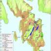
A dam and sluice, now submerged, were constructed at Loch Dhu to supplement and control the water supply into the Scalpsie Cut (NS05NE 79), part of the system of water channels constructed to supply the Rothesay Cotton Mill (NS06SE 5) by Robert Thom. A sluice and what may be two dams were depicted on the 1st edition of the OS 6-inch map (Buteshire 1869, Sheet CCIV).
Information from RCAHMS (GFG) 17 May 2010.
Desk Based Assessment (17 May 2010)
A dam and sluice, now submerged, were constructed at Loch Dhu to supplement and control the water supply into the Scalpsie Cut (NS05NE 79), part of the system of water channels constructed to supply the Rothesay Cotton Mill (40417) by Robert Thom. A sluice and what may be two dams were depicted on the 1st edition of the OS 6-inch map (Buteshire 1869, Sheet CCIV).
Information from RCAHMS (GFG) 17 May 2010.

