
Bute, Achavoulaig


Farmstead (19th Century)-(20th Century), Horse Engine (19th Century)-(20th Century)
Site Name Bute, Achavoulaig
Classification Farmstead (19th Century)-(20th Century), Horse Engine (19th Century)-(20th Century)
Canmore ID 301013
Site Number NS06NW 100
NGR NS 02446 68576
Datum OSGB36 - NGR
Permalink http://canmore.org.uk/site/301013


- Council Argyll And Bute
- Parish North Bute
- Former Region Strathclyde
- Former District Argyll And Bute
- Former County Buteshire
NS06NW 100 02446 68576
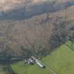
Achavoulaig is a working farmsteading containing a mixture of 19th and 20th century buildings and sheds, none of which have been recorded in detail. There was no farmsteading here in the 18th century when the area was mapped by Roy (1747-55) and May (1780), the land, which formed part of ‘Drumochloy’, being mainly moor, with only relatively small patches of cultivation. Even as late as the 1820s the main farmstead (NS06NW 70) in the area was situated some 400m to the NW, and settlement is first shown here on the 1st edition of the OS 6-inch map (Argyllshire and Buteshire 1869, Sheet CXCIII). ‘Achawillag’ comprised buildings around four sides of a yard with narrow gaps at the NW ends of the NE and SW sides. An L-plan range that occupied the NE and SE sides of the yard contained a farmhouse in its NE wing with a garden immediately NE. The 2nd edition of the OS 25-inch map (1897, Sheet CXCIII.16) shows that among the additions made to the steading in the late 19th century was a horse-engine adjacent to the SE side of the SE range.
Visited by RCAHMS (GFG) 22 March 2009.
Field Visit (1864)
Reference (1951)
Field Visit (22 March 2009)
Achavoulaig is a working farmsteading containing a mixture of 19th and 20th century buildings and sheds, none of which have been recorded in detail. There was no farmsteading here in the 18th century when the area was mapped by Roy (1747-55) and May (1780), the land, which formed part of ‘Drumochloy’, being mainly moor, with only relatively small patches of cultivation. Even as late as the 1820s the main farmstead (NS06NW 70) in the area was situated some 400m to the NW, and settlement is first shown here on the 1st edition of the OS 6-inch map (Argyllshire and Buteshire 1869, Sheet CXCIII). ‘Achawillag’ comprised buildings around four sides of a yard with narrow gaps at the NW ends of the NE and SW sides. An L-plan range that occupied the NE and SE sides of the yard contained a farmhouse in its NE wing with a garden immediately NE. The 2nd edition of the OS 25-inch map (1897, Sheet CXCIII.16) shows that among the additions made to the steading in the late 19th century was a horse-engine adjacent to the SE side of the SE range.
Visited by RCAHMS (GFG) 22 March 2009.

