
Bute, Scalpsie Water Cut


Bridge(S) (19th Century), Sluice(S) (19th Century), Water Channel (19th Century)
Site Name Bute, Scalpsie Water Cut
Classification Bridge(S) (19th Century), Sluice(S) (19th Century), Water Channel (19th Century)
Alternative Name(s) Rothesay Cotton Mills; Robert Thom's Water Cuts; Barmore Cut; Quien Cut
Canmore ID 241947
Site Number NS05NE 79
NGR NS 0579 5916
Datum OSGB36 - NGR
Permalink http://canmore.org.uk/site/241947


- Council Argyll And Bute
- Parish North Bute
- Former Region Strathclyde
- Former District Argyll And Bute
- Former County Buteshire
NS05NE 79 0513 5833
See also: NS06SE 5 0865 6459 Rothesay cotton mill
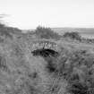
(Location cited as NS 053 585). Scalpsie, engineer Robert Thom. The remains of the extensive water cuts made by Thom to supply water to the Rothesay cotton mills. There is a small segmental-arched accommodation bridge. The cuts fed into Loch Quien, thence into Loch Fad and the Kirk Dam.
J R Hume 1977.
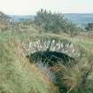
Scalpsie Water Cut (mid-point NS 0579 5916), one of the channels constructed by Robert Thom to power the Rothesay cotton mill (NS06SE 5), carried water from a natural burn at NS 0481 5894 around the base of Tarmore and Quien Hill, emptying into Loch Fad, at NS 0681 6030, 2.4km to the NE. The natural burn flowed from Loch Dhu, which was dammed at the same time (NS06SE 427), and a second dam further downstream helped to control and supplement the flow (NS05NE 121). There were a total of 21 bridges and four sluices on the cut (Maclagan 1996, 9-11), one of which was recorded by John Hume in 1971 (Hume 1977). A second was noted by RCAHMS in 2009, and is recorded elsewhere (NS05NE 120).
Information from RCAHMS (GFG) 25 May 2010.
Field Visit (16 February 1971)
(Location cited as NS 053 585). Scalpsie, engineer Robert Thom. The remains of the extensive water cuts made by Thom to supply water to the Rothesay cotton mills. There is a small segmental-arched accommodation bridge. The cuts fed into Loch Quien, thence into Loch Fad and the Kirk Dam.
J R Hume 1977.
Desk Based Assessment (18 May 2010)
Scalpsie Water Cut (mid-point NS 0579 5916), one of the channels constructed by Robert Thom to power the Rothesay cotton mill (NS06SE 5), carried water from a natural burn at NS 0481 5894 around the base of Tarmore and Quien Hill, emptying into Loch Fad, at NS 0681 6030, 2.4km to the NE. The natural burn flowed from Loch Dhu, which was dammed at the same time (NS06SE 427), and a second dam further downstream helped to control and supplement the flow (NS05NE 121). There were a total of 21 bridges and four sluices on the cut (Maclagan 1996, 9-11), one of which was recorded by John Hume in 1971 (Hume 1977). A second was noted by RCAHMS in 2009, and is recorded elsewhere (NS05NE 120).
Information from RCAHMS (GFG) 25 May 2010.

