
Bute, Loch Quien


Bridge (Period Unassigned), Rig And Furrow (Medieval), Track (Period Unassigned)
Site Name Bute, Loch Quien
Classification Bridge (Period Unassigned), Rig And Furrow (Medieval), Track (Period Unassigned)
Alternative Name(s) Rothesay Cotton Mills; Robert Thom Water Cuts
Canmore ID 304525
Site Number NS05NE 120
NGR NS 06232 59573
Datum OSGB36 - NGR
Permalink http://canmore.org.uk/site/304525


- Council Argyll And Bute
- Parish North Bute
- Former Region Strathclyde
- Former District Argyll And Bute
- Former County Buteshire
NS05NE 120 06232 59573
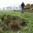
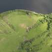
This single-span, arched bridge crosses Thom's Cut (NS05NE 79) in a field of pasture immediately W of Loch Quien. A trackway runs over the bridge.
Visited by RCAHMS (LD, GB) 3 April 2009.
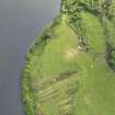
Aerial photography has recorded the remains of rig and furrow cultivation in the field immediately SE of the bridge.
Information from RCAHMS (GFG) 2 February 2010.
Field Visit (3 April 2009)
This single-span, arched bridge crosses Thom's Cut (NS05NE 79) in a field of pasture immediately W of Loch Quien. A trackway runs over the bridge.
Visited by RCAHMS (LD, GB) 3 April 2009.

