
South Uist, Airigh-mhuilinn


Corn Drying Kiln (Period Unassigned), Township (Period Unassigned)
Site Name South Uist, Airigh-mhuilinn
Classification Corn Drying Kiln (Period Unassigned), Township (Period Unassigned)
Alternative Name(s) Milton
Canmore ID 83280
Site Number NF72NW 28
NGR NF 741 268
NGR Description Centred NF 741 268
Datum OSGB36 - NGR
Permalink http://canmore.org.uk/site/83280


- Council Western Isles
- Parish South Uist
- Former Region Western Isles Islands Area
- Former District Western Isles
- Former County Inverness-shire
NF72NW 28 centred 741 268
(previously recorded at NF 745 266 [NGR of name on 1:10000 map])
Airidh-Mhuilinn [name changed to Airigh-Mhuilinn on later editions of OS maps - at NF 745 266 on OS 1:10,000 map, 1971]: A green mound on which there are a number of ruins, one of which is pointed out as being the birthplace of Flora McDonald [in 1722].
Name Book, Inverness-shire (Hebrides), 1878
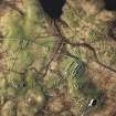
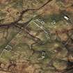
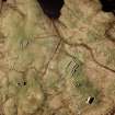
Airigh-Mhuilinn was surveyed by students from Sheffield University in 1993. Here are the ruins of fifteen pre-Clearance dwellings, some with associated byres or outhouses and yards or gardens. The houses are located on small areas of higher, drier land in a zone dissected by water-courses and boggy ground, surrounded by more extensive dry ridges which were used for cultivation. The sketch plan has picked up a very extensive pattern of spade-ridges, produced by the cas-chrom or foot-plough, and the metre-wide ridges last used for potatoes may be distinguished from the 1.5m wide ridges on which cereals were grown. There are also smaller potato-patches, dug by crofters in more recent times. What is probably the most important structure is a large rectangular walled enclosure, originally built in orthostatic 'post and panel' style and later refurbished. If this was the tacksman's cattle enclosure, there might be four possible birthplaces for Flora McDonald - the house within the enclosure, the house incorporated into its SW corner, and the two sizeable houses immediately outside the enclosure, one to the N, the other to the E.
MS 595/9
NF 764 474 to NF 758 140 The South Uist machair has been surveyed between 1993-1996, from Cille Bhrighde (West Kilbride) in the extreme S of the island to Baile Gharbhaidh (Balgarva) at the N end of the island, a distance of 35km. This year, the number of known prehistoric and Early Historic settlement sites has now increased from 81 to 176.
The continuing pattern of Iron Age-Viking Age settlement clusters along the machair supports the hypothesis of 'proto-townships'; that the system of land allotment amongst the townships is essentially an Iron Age phenomenon which survived substantially intact until the Clearances of the early 19th century (see unpublished reports, Sheffield University). An unusual concentration of sites was found at Machair Mheadhanach in the Iochdar (Eochar) area, N of the rocket range and W of Loch Bee; some 35 settlement sites, ranging in date from the Late Bronze Age to the early post-medieval period, are strung out within a 2km line along a NW-SE axis. This multifocal pattern is very different from other settlement patterns on South Uist but still fits the 'proto-township' model.
The second major concentration of sites is at Drimore where a group of 14 settlement sites, of various dates, are arranged in a SSE-NNW line 750m long. Most of these were identified in the 1950s during survey and excavation in advance of the construction of the rocket range.
The pattern of hypothesised proto-townships throughout the survey area (unpublished report, Sheffield University) holds reasonably well but there are gaps for each of the six 'shieling' (gearraidh) townships of South Uist. This suggests that these shieling townships may have formed in the medieval period by sub-division of larger units, and thus do not have prehistoric predecessors. Other medieval peatland settlements are tentatively identified at Upper Bornish, Aisgernis (Askernish), Frobost and Cille Pheadair (Kilpheder). There is a strong possibility that most of the nucleated villages mapped by William Bald in 1805 are located on earlier post-medieval and medieval settlements. The movement of settlement off the machair mainly occurred in the post-Norse medieval period. The only exceptions are Baghasdal, where the machair settlement was abandoned only after 1805 supposedly due to 'machair fever' (James MacDonald pers comm), and Machair Mheadhanach which was deserted some time between 1654 and 1805.
Sponsor: Sheffield University.
M Parker Pearson 1996
Fifteen unroofed buildings and two enclosures are depicted on the 1st edition of the OS 6-inch map (Inverness-shire, Hebrides, South Uist 1881, sheet lv). One roofed, one partially roofed, seven unroofed buildings and three enclosures are shown on the current edition of the OS 1:10000 map (1971).
Information from RCAHMS (SAH) 20 May 1997
NF 740 270 (centre) A landscape survey of the archaeological remains in the 19th-century township of Milton, South Uist, was carried out in July 1997. The work focused on the machair and blacklands to the W of the island. The hills to the E were not intensively surveyed but were examined briefly. Over 1200 separate features were identified in the machair and blacklands area. These ranged from formal cairns to clearance cairns, settlement remains, platforms, trackways, field walls and extensive cultivation rigs. In the hills a complex series of large dykes and several shielings were identified. The focus upon one township and integration with ongoing excavation and survey in the settlement core has contributed to our understanding of alterations in the structure of the agricultural landscape in Milton township from the medieval period through to the present day. This includes hints of a pre-run-rig system of enclosures as well as run-rig and crofting landscapes.
Full details have been lodged with the NMRS.
Sponsors: Historic Scotland, Earthwatch.
J Symonds, J Lund and G Warren 1998
NF 741 269 (centre) In 1997 excavation and geophysical survey were carried out in the settlement at Airigh Mhuilinn (see Parker Pearson 1996). The interior of a blackhouse was fully excavated. A small structure containing a corn dryer was also partially excavated.
Excavation inside the blackhouse revealed internal drains and divisions, and a variety of ceramic, glass and metal artefacts, dating from 1800?30. Some of the pottery was of high quality, and much had been imported from Stoke-on-Trent and Glasgow. Excavation in the adjoining kailyard revealed a large surface paved with beach cobbles, and a haystack base. Samples were taken for phosphate analysis and environmental processing.
Sponsors: Society of Antiquaries of Scotland, Earthwatch.
J Symonds 1998
NF 741 269 (centre) In June and July 2000 a further season of excavation and field survey was conducted at Airigh Mhuilinn. Excavation of House J, the fifth blackhouse to be completely excavated since 1996 (DES 1998, 101), exposed the remains of a substantial stone structure. The structure was sub-rectangular, with rounded end walls and internal dimensions of c 16.2 x 3.8m. The walls were c 1-1.4m thick, and comprised an inner and outer skin of undressed gneiss boulders with a tempered-earth core. A single doorway (c 0.75m wide) was located on the W side of the house, c 5.5m from the S end.
The structure was aligned N-S, and had been carefully sited to make use of a natural slope on a hummock of morainic drift. In its original form the house had been divided into three rooms. The house was entered through the byre area (c 5.15 x 3.8m) at the foot of the slope. A stone-capped drain ran N-S down the centre of the byre, emptying through a hole in the end wall. The byre was separated from the main living area of the house by a short partition wall. Beyond this, to the N, the main living room (c 8 x 3.8m) contained the remains of a central hearth. At the extreme N end of the house a smaller area (c 3 x 3.8m) had been demarcated as a sleeping area. Excavated finds from the floor deposits of the living area and byre include several glass beads, some of which may have derived from a rosary, and ceramics dating from the 1820s. A programme of bulk environmental and geochemical (phosphate and magnetic susceptibility) sampling was undertaken on floor deposits within the house and byre. The results of this work are being analysed.
After abandonment parts of the main structure were heavily robbed. A small V-shaped setting of stones (c 2.88 x 1.83m at base) was laid out in the former living area, presumably to serve as a lambing pen. The house and byre were bisected NW-SE by a line of stones that supported wooden posts and a barbed-wire fence, when the area was made over to croft land in 1917.
A handful of sherds of an undiagnostic coarse gneiss-tempered pottery were found in shallow depressions in the subsoil/bedrock beside the blackhouse. These finds may be examples of hand-made 19th-century pottery (Craggan-type ware) associated with the use of the house, or alternatively may indicate prehistoric or medieval activity on the site. One fragment of a snapped flint blade was recovered from a test trench to the E of the blackhouse excavation.
A corn-drying kiln butting up against the N wall of the blackhouse was also excavated. This ancillary structure (4.3 x 2.2m internally) had been constructed at some point during the primary occupation of the blackhouse. This corn dryer had randomly coursed stone walls (c 0.7m thick) on the N side. These walls thickened to include rubble and clay packing in the area surrounding the actual kiln. The flue had been badly robbed, but a small circular bowl (diameter c 0.9m at top, 0.3m at base) survived. Bulk environmental samples were taken from the bowl and threshing floor within this structure, and are in the process of being analysed.
Sponsors: Boston University, Earthwatch.
J Symonds, A Badcock, V Parsons and S Brighton 2000
Project (6 September 2005 - 8 September 2005)
Scottish and Southern Electricity Plc commissioned SUAT Ltd to undertake an archaeological walkover survey on the route of overhead power cables running from Drimore to North Glendale on the island of South Uist, Western Isles. The survey was to be conducted in advance of refurbishment of the poles supporting the power cables, commencing at NGR NF 7690 4035 and proceeding southwards over a distance of approximately 25km. The work (SUAT site code SU01) was undertaken during the period 6th-8th September 2005 in varying weather conditions including both bright sunshine and rain squalls.
The requirement was to evaluate those sections of the line where groundworks or vehicle access would be necessary, assessing the possible impact of the work on known or previously unrecorded archaeological sites, as well as locating and describing the latter. Four previously unrecorded sets of features were noted on known sites, while a mitigation strategy agreed with SSE ensured that the refurbishment work was able to proceed without disturbance or damage to the archaeology of South Uist.
SUAT Ltd. 2005

